IMAGES TAKEN NEAR TO
Maze Street, BRISTOL, BS5 9TQ
Introduction
This page details the photographs taken nearby to Maze Street, BS5 9TQ by members of the Geograph project.
The Geograph project started in 2005 with the aim of publishing, organising and preserving representative images for every square kilometre of Great Britain, Ireland and the Isle of Man.

There are currently over 7.5m images from over14,400 individuals and you can help contribute to the project by visiting https://www.geograph.org.uk
Image Map
Images are licensed for reuse under creativecommons.org/licenses/by-sa/2.0
Notes
- Clicking on the map will re-center to the selected point.
- The higher the marker number, the further away the image location is from the centre of the postcode.
Image Listing (86 Images Found)
Images are licensed for reuse under creativecommons.org/licenses/by-sa/2.0
Image
Details
Distance
1
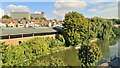
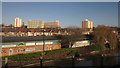
River Avon
Looking towards Phoenix House and Ecclseton House
Image: © Chris Morgan
Taken: 23 Sep 2022
0.08 miles
5
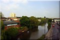
Industry by The Feeder
Industrial units on the Barton Hill Trading Estate, beside The Feeder, a canal that links Bristol's Floating Harbour to the River Avon upstream. The prominent buildings in the background are (left) Hanwood House, St Luke's Church, Phoenix House, Eccleston House and (right) Barton House. View from the railway line between Bath and Bristol Temple Meads; Image gives a similar view.
Image: © Derek Harper
Taken: 23 Nov 2012
0.10 miles
6
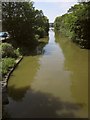
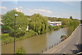
The Feeder
The straight canal, looking west from Barton Hill Bridge. The car is on the parallel Feeder Road.
Image: © Derek Harper
Taken: 13 Jul 2013
0.11 miles
8
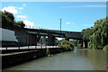
Road and rail bridges crossing the Bristol Harbour feeder canal, entering Bristol.
This is the feeder canal leading from the river Avon into Bristol Floating Harbour.
Image: © Martyn Pattison
Taken: 2 Aug 2005
0.11 miles
9
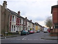
Glendare Street
This old residential road is in Barton Hill and runs from Marsh Lane next to the recreation ground to Great Western Lane. It contains a variety of terraced housing mainly from the late 19th C and early 20th C.
Image: © Nigel Mykura
Taken: 23 Feb 2013
0.12 miles
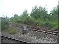
10
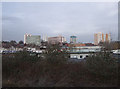
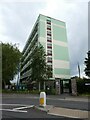
Barton Hill flats
Barton Hill flats, taken from the train on the London to Bristol Temple Meads mainline.
Image: © Vieve Forward
Taken: 6 Feb 2012
0.13 miles