IMAGES TAKEN NEAR TO
Orchard Square, BRISTOL, BS5 9RJ
Introduction
This page details the photographs taken nearby to Orchard Square, BS5 9RJ by members of the Geograph project.
The Geograph project started in 2005 with the aim of publishing, organising and preserving representative images for every square kilometre of Great Britain, Ireland and the Isle of Man.

There are currently over 7.5m images from over14,400 individuals and you can help contribute to the project by visiting https://www.geograph.org.uk
Image Map
Images are licensed for reuse under creativecommons.org/licenses/by-sa/2.0
Notes
- Clicking on the map will re-center to the selected point.
- The higher the marker number, the further away the image location is from the centre of the postcode.
Image Listing (84 Images Found)
Images are licensed for reuse under creativecommons.org/licenses/by-sa/2.0
Image
Details
Distance
1
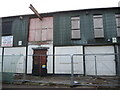
Going through many changes
An industrial unit on Netham Road is looking like it is about to go. A few small businesses still operated here in less than opulent surroundings. This latter twentieth century building was once a leather dressing factory, but has gone through many changes of occupation since.
Image: © Neil Owen
Taken: 2 Feb 2022
0.02 miles
2
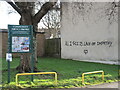
All I see is lack of empathy
Meaningful words along Avonvale Road. It looks like the previous meaningful words have been erased.
Image: © Neil Owen
Taken: 2 Feb 2022
0.03 miles
3
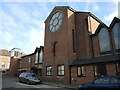
St Patrick's Roman Catholic church
A modern brick-built church and residential estate, on what was the old church school playing field in Pile Marsh.
Image: © Neil Owen
Taken: 2 Feb 2022
0.06 miles
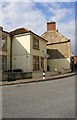
5
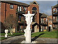
Welcoming arms by St Patrick's
A Roman Catholic church has created a small group of houses around it, including this fine statue.
Image: © Neil Owen
Taken: 2 Feb 2022
0.07 miles
6
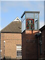
St Patrick in colour
The new church in Pile Marsh has a tower feature with some stained glass effects.
Image: © Neil Owen
Taken: 2 Feb 2022
0.07 miles
7
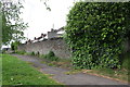
Path to the recreation ground
A path leading onto Netham recreation ground from Avonvale Road.
Image: © DS Pugh
Taken: 27 Jun 2017
0.08 miles
9
Footpath through Recreation Ground behind Cooperage Road houses
There is an OS benchmark Image on the wall right of the large thistle in the middle of the image
Image: © Roger Templeman
Taken: 2 May 2017
0.09 miles
10
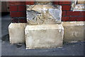
Benchmark on former Hauliers Arms pub
Ordnance Survey cut mark benchmark described on the Bench Mark Database at http://www.bench-marks.org.uk/bm80622
Image: © Roger Templeman
Taken: 2 May 2017
0.09 miles