IMAGES TAKEN NEAR TO
Baden Road, BRISTOL, BS5 9QE
Introduction
This page details the photographs taken nearby to Baden Road, BS5 9QE by members of the Geograph project.
The Geograph project started in 2005 with the aim of publishing, organising and preserving representative images for every square kilometre of Great Britain, Ireland and the Isle of Man.

There are currently over 7.5m images from over14,400 individuals and you can help contribute to the project by visiting https://www.geograph.org.uk
Image Map
Images are licensed for reuse under creativecommons.org/licenses/by-sa/2.0
Notes
- Clicking on the map will re-center to the selected point.
- The higher the marker number, the further away the image location is from the centre of the postcode.
Image Listing (82 Images Found)
Images are licensed for reuse under creativecommons.org/licenses/by-sa/2.0
Image
Details
Distance
3
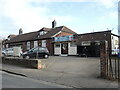
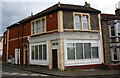
St Anne's Board Mills Social Club
The St Anne's Board Mills started operating on a massive new site on the other side of the River Avon, less than a mile away. The company began as Mardon, Son and Hall as suppliers to the tobacco trade in the nineteenth century. After increasing the printing and packaging business the St Anne's site was chosen to build new premises. The company employed hundreds of local people at its peak and this social club was provided for them. Although the presses and machinery are now history, the social club lives on.
Image: © Neil Owen
Taken: 2 Feb 2022
0.04 miles
4
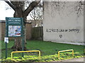
All I see is lack of empathy
Meaningful words along Avonvale Road. It looks like the previous meaningful words have been erased.
Image: © Neil Owen
Taken: 2 Feb 2022
0.05 miles
5
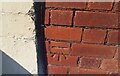
Ordnance Survey Cut Mark
This OS cut mark can be found on what was No140 Hayward Road. It marks a point 28.011m above mean sea level.
Image: © Adrian Dust
Taken: 19 Jul 2021
0.06 miles
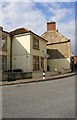
6
#140 Hayward Road at Baden Road junction
There is an OS benchmark Image on the left hand side of the house, just beyond the two white cabinets
Image: © Roger Templeman
Taken: 2 May 2017
0.06 miles
7

Benchmark on #140 Hayward Road Flat 2, Baden Road face
Ordnance Survey cut mark benchmark described on the Bench Mark Database at http://www.bench-marks.org.uk/bm84276
Image: © Roger Templeman
Taken: 2 May 2017
0.06 miles
8
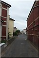
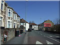
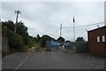
Baden Road
A narrow street between Victoria Avenue and Roseberry Road.
Image: © DS Pugh
Taken: 27 Jun 2017
0.06 miles
10
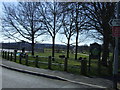
Path to the recreation ground
A path leading onto Netham recreation ground from Avonvale Road.
Image: © DS Pugh
Taken: 27 Jun 2017
0.06 miles