IMAGES TAKEN NEAR TO
Church Road, BRISTOL, BS5 9HX
Introduction
This page details the photographs taken nearby to Church Road, BS5 9HX by members of the Geograph project.
The Geograph project started in 2005 with the aim of publishing, organising and preserving representative images for every square kilometre of Great Britain, Ireland and the Isle of Man.

There are currently over 7.5m images from over14,400 individuals and you can help contribute to the project by visiting https://www.geograph.org.uk
Image Map
Images are licensed for reuse under creativecommons.org/licenses/by-sa/2.0
Notes
- Clicking on the map will re-center to the selected point.
- The higher the marker number, the further away the image location is from the centre of the postcode.
Image Listing (74 Images Found)
Images are licensed for reuse under creativecommons.org/licenses/by-sa/2.0
Image
Details
Distance
1
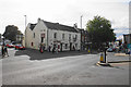
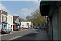
The Fire Engine and Church Road
Church Road continues down past the pub, being the main shopping street in Redfield.
Image: © Bill Boaden
Taken: 28 Sep 2017
0.02 miles
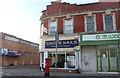
2
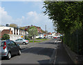
2011 : Derby Street, Redfield, Bristol
Looking east, Blackswarth Road is at the far end.
The large red brick building in the distance is St.George Grammar School.
Image: © Maurice Pullin
Taken: 17 Apr 2011
0.03 miles
3
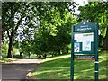
Entrance to St. George Park
St. George Park is a park on the eastern edge of the inner city in Bristol, England.
Image: © Duncan Gammon
Taken: 23 Jun 2006
0.04 miles
4
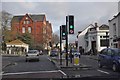
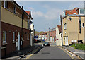
Bristol : Church Lane
Church Lane at the traffic lights and pedestrian crossing.
Image: © Lewis Clarke
Taken: 1 Feb 2013
0.04 miles
5
2011 : A420 Church Road, Redfield, Bristol
Heading east into St.George.
A scene full of interest for anyone looking at the larger version.
Image: © Maurice Pullin
Taken: 17 Apr 2011
0.04 miles
6
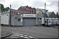
Fire Engine Garage
The Fire Engine Garage, Blackswarth Road, Bristol, Avon - possibly St George's old fire station.
Image: © Kevin Hale
Taken: 26 Jul 2009
0.04 miles
7
2011 : Barnes Street, Redfield, Bristol
A420 Church Road crosses, beyond is Roseberry Park.
Image: © Maurice Pullin
Taken: 17 Apr 2011
0.05 miles
9
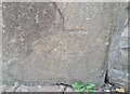
Ordnance Survey Cut Mark
This OS cut mark can be found on the gatepost at the entrance to St George's Park. It marks a point 38.036m above mean sea level.
Image: © Adrian Dust
Taken: 19 Jul 2021
0.05 miles
10
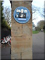
Local history in St George
The entrance to the park is emhanced with a local history plaque. It chiefly marks the area where entertainer Bob Hope once lived in as a child. It also mentions other interesting events and people, including the Elizabeth Shaw factory that made chocolates. Below is an engraving the name of the surveyor, Lawrence Lewis, dated 1897; on the other entrance pillar is engraved 'Joseph Stubbs, Clerk'.
Image: © Neil Owen
Taken: 2 Feb 2022
0.05 miles