IMAGES TAKEN NEAR TO
Milton Park, BRISTOL, BS5 9HQ
Introduction
This page details the photographs taken nearby to Milton Park, BS5 9HQ by members of the Geograph project.
The Geograph project started in 2005 with the aim of publishing, organising and preserving representative images for every square kilometre of Great Britain, Ireland and the Isle of Man.

There are currently over 7.5m images from over14,400 individuals and you can help contribute to the project by visiting https://www.geograph.org.uk
Image Map
Images are licensed for reuse under creativecommons.org/licenses/by-sa/2.0
Notes
- Clicking on the map will re-center to the selected point.
- The higher the marker number, the further away the image location is from the centre of the postcode.
Image Listing (84 Images Found)
Images are licensed for reuse under creativecommons.org/licenses/by-sa/2.0
Image
Details
Distance
1
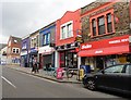
Parade of shops and post office, Church Road
Image: © Roger Cornfoot
Taken: 24 Apr 2017
0.05 miles
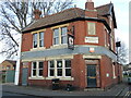
2
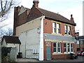
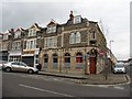
A lone hop pole
This end-of-the-terrace pub was part of the Victorian expansion of this part of Bristol, previously being just a house before being granted a license. However, the rest of the houses on Avonvale Road are gone, as is much of the area when the post-war redevelopment came about. The pub remained, although the end wall shows the missing structures. Sadly the pub itself closed in recent years but has been saved as a converted residential space.
Image: © Neil Owen
Taken: 2 Feb 2022
0.06 miles
3
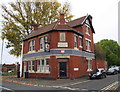
Hop Pole Court at junction of Avondale Road and Gladstone Street
There is an OS benchmark Image on the left hand face of the former pub, just left of the 45-degree face with the building's front door
Image: © Roger Templeman
Taken: 29 Oct 2016
0.06 miles
5
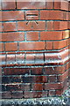
Benchmark on #27 Avondale Road, 'Hop Pole Court'
Ordnance Survey cut mark benchmark described on the Bench Mark Database at http://www.bench-marks.org.uk/bm80345
Image: © Roger Templeman
Taken: 29 Oct 2016
0.06 miles
6
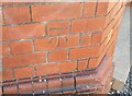
Ordnance Survey Cut Mark
This OS cut mark can be found on the Hop Pole Inn. It marks a point 34.342m above mean sea level.
Image: © Adrian Dust
Taken: 19 Jul 2021
0.06 miles
7
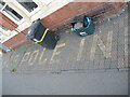
Set into the tiles of the pub
The Hop Pole Inn has made sure its name will not fade, even though it stopped serving some time ago and is now residential. See Image] for a wider view of what is left.
Image: © Neil Owen
Taken: 2 Feb 2022
0.06 miles
8
Smaller doors
The former Hop Pole pub is now residential, after serving its last pint. To signify the reduction of welcome, the doorways are reduced by more brickwork. See Image] for a look at the floor outside the windows.
Image: © Neil Owen
Taken: 2 Feb 2022
0.06 miles
10
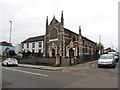
The Hindu Temple, Church Road, Bristol
Image: © Roger Cornfoot
Taken: 24 Apr 2017
0.07 miles