IMAGES TAKEN NEAR TO
Victoria Parade, BRISTOL, BS5 9DZ
Introduction
This page details the photographs taken nearby to Victoria Parade, BS5 9DZ by members of the Geograph project.
The Geograph project started in 2005 with the aim of publishing, organising and preserving representative images for every square kilometre of Great Britain, Ireland and the Isle of Man.

There are currently over 7.5m images from over14,400 individuals and you can help contribute to the project by visiting https://www.geograph.org.uk
Image Map
Images are licensed for reuse under creativecommons.org/licenses/by-sa/2.0
Notes
- Clicking on the map will re-center to the selected point.
- The higher the marker number, the further away the image location is from the centre of the postcode.
Image Listing (73 Images Found)
Images are licensed for reuse under creativecommons.org/licenses/by-sa/2.0
Image
Details
Distance
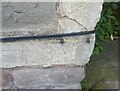
1
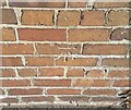
Ordnance Survey Cut Mark
This OS cut mark can be found on No36 Victoria Parade. It marks a point 29.986m above mean sea level.
Image: © Adrian Dust
Taken: 19 Jul 2021
0.03 miles
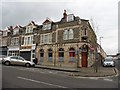
2
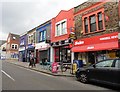
Parade of shops and post office, Church Road
Image: © Roger Cornfoot
Taken: 24 Apr 2017
0.06 miles
3
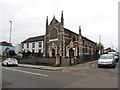
The Hindu Temple, Church Road, Bristol
Image: © Roger Cornfoot
Taken: 24 Apr 2017
0.07 miles
4
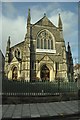
Bristol : The Hindu Temple
The Hindu Temple in Bristol on Church Lane.
Image: © Lewis Clarke
Taken: 1 Feb 2013
0.07 miles
5
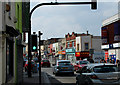
2011 : A420 Church Road, St.George, Bristol
Looking west toward the city centre. The Casino stands on the corner of Lyppiatt Road, this is a sunday so shutters on neighbouring shops is not necessarily a bad sign. A barbers shop is to the left. All these premises are pre 1910 except the Tesco Metro.
Image: © Maurice Pullin
Taken: 17 Apr 2011
0.08 miles
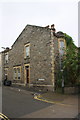
6
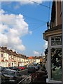
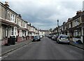
A typical Redfield Street
Victorian terraces in Redfield / St George
Image: © Duncan Gammon
Taken: 23 Jun 2006
0.09 miles
9
Ordnance Survey Cut Mark
This OS cut mark can be found on No102 Church Road. It marks a point 26.316m above mean sea level.
Image: © Adrian Dust
Taken: 19 Jul 2021
0.12 miles
10
#102 Church Road at junction with Witchell Road
There is an OS benchmark Image on the wide corner stone above 4 small stone quoins at the near corner, left hand face, of the house
Image: © Roger Templeman
Taken: 29 Oct 2016
0.12 miles