IMAGES TAKEN NEAR TO
Parslows Barton, BRISTOL, BS5 8QH
Introduction
This page details the photographs taken nearby to Parslows Barton, BS5 8QH by members of the Geograph project.
The Geograph project started in 2005 with the aim of publishing, organising and preserving representative images for every square kilometre of Great Britain, Ireland and the Isle of Man.

There are currently over 7.5m images from over14,400 individuals and you can help contribute to the project by visiting https://www.geograph.org.uk
Image Map
Images are licensed for reuse under creativecommons.org/licenses/by-sa/2.0
Notes
- Clicking on the map will re-center to the selected point.
- The higher the marker number, the further away the image location is from the centre of the postcode.
Image Listing (22 Images Found)
Images are licensed for reuse under creativecommons.org/licenses/by-sa/2.0
Image
Details
Distance
1
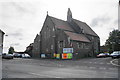
St Aidan with St George
An Anglican church which also hosts regular arts events.
Image: © Bill Boaden
Taken: 28 Sep 2017
0.06 miles
2
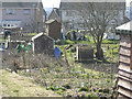
The Allotments, Nicholas Lane, Bristol
The allotments, looking south towards the rear of the houses on Nibblets Hill taken from near the allotment shop.
Image: © Andy Gilbert
Taken: 6 Mar 2005
0.10 miles
3
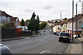
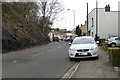
Nags Head Hill
Showing some of the gradients in the eastern suburbs of Bristol.
Image: © Bill Boaden
Taken: 28 Sep 2017
0.10 miles
4
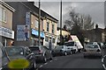
Bristol : Nags Head Hill
The Road heads up the hill - and Where's Wally?
Image: © Lewis Clarke
Taken: 1 Feb 2013
0.10 miles
5
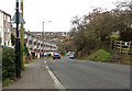
2010 : Troopers Hill Road going up
Crew's Hole Road is at the bottom, Air Balloon Road and Nags Head Hill on the A431 at the top.
The gentle slope of Troopers Hill is to the left, an area made interesting by mining, slag heaps and quarries now a nature reserve. Worth a visit on a fine clear day.
Image: © Maurice Pullin
Taken: 26 Nov 2010
0.11 miles
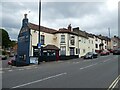
7
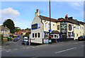
The Lord Raglan
A pub at the meeting of Nags Head Hill and Stibbs Hill.
Image: © Bill Boaden
Taken: 28 Sep 2017
0.12 miles
8
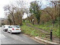
Access to Troopers hill Nature Reserve
Once a mining area now given over to nature.
Image: © Anthony Vosper
Taken: 3 Mar 2024
0.14 miles
10
2010 : Troopers Hill Road, St.George, Bristol
Troopers Hill is steep all the way down from Air Balloon Road to Crew's Hole Road at the bottom, this is the really steep bit.
The footpath on the right leads to Troopers Hill proper, an area where coal and copper were mined and clay for bricks was quarried. It is now a nature reserve.
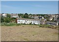
Houses in St. Anne's Park on the other side of the Bristol Avon are seen in the background.
Image: © Maurice Pullin
Taken: 26 Nov 2010
0.15 miles