IMAGES TAKEN NEAR TO
Weavers Mill Close, BRISTOL, BS5 8FH
Introduction
This page details the photographs taken nearby to Weavers Mill Close, BS5 8FH by members of the Geograph project.
The Geograph project started in 2005 with the aim of publishing, organising and preserving representative images for every square kilometre of Great Britain, Ireland and the Isle of Man.

There are currently over 7.5m images from over14,400 individuals and you can help contribute to the project by visiting https://www.geograph.org.uk
Image Map
Images are licensed for reuse under creativecommons.org/licenses/by-sa/2.0
Notes
- Clicking on the map will re-center to the selected point.
- The higher the marker number, the further away the image location is from the centre of the postcode.
Image Listing (59 Images Found)
Images are licensed for reuse under creativecommons.org/licenses/by-sa/2.0
Image
Details
Distance
1
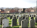
Moving in on the plots
Avon View Cemetery expanded and swallowed up more land as time went on, only to be outdone by the increase in the need for housing. St Patrick's View has a row of new homes for company.
Image: © Neil Owen
Taken: 2 Feb 2022
0.10 miles
2
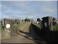
Entrance to Avon View Cemetery from Blackswarth Road
A dead straight path into the lower end of the cemetery lies on what were previously allotments. Quarrying was a major industry just further towards the river.
Image: © Neil Owen
Taken: 2 Feb 2022
0.11 miles
3
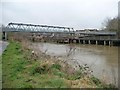
St Anne's Footbridge
The northern end of the bridge across the Avon shown in Image] is just in this square.
Image: © Derek Harper
Taken: 13 Jul 2013
0.11 miles
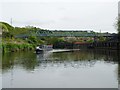
4
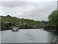
Trip boat on the Avon, south-west of St Anne's Footbridge
Heading downstream with an afternoon party.
Image: © Christine Johnstone
Taken: 3 May 2015
0.11 miles
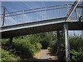
5
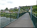
Footbridge, St Anne's
Opened in 1958 as a replacement for the river ferry, once located at this point since the middle ages.
Image: © Roger Cornfoot
Taken: 7 Jun 2021
0.11 miles
6
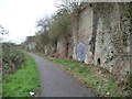
Blocked entrance alongside the River Avon towpath
Once giving access to industrial premises above.
Image: © Christine Johnstone
Taken: 23 Mar 2013
0.12 miles
7
Narrowboat on the Avon at St Anne's Footbridge
Seen from the west as it heads downstream.
Image: © Christine Johnstone
Taken: 4 May 2015
0.12 miles
8
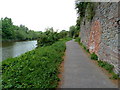
Monarch's Way along the River Avon near Netham
Image: © Anthony O'Neil
Taken: 29 Apr 2011
0.12 miles
9
St Anne's footbridge, from downstream
With a long accessible ramp on the opposite bank.
Image: © Christine Johnstone
Taken: 23 Mar 2013
0.12 miles
10
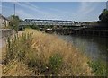
St Anne's Footbridge
Another view of the bridge shown in http://www.geograph.org.uk/search.php?i=42743940 .
Image: © Derek Harper
Taken: 13 Jul 2013
0.12 miles