IMAGES TAKEN NEAR TO
Bennett Road, BRISTOL, BS5 8EY
Introduction
This page details the photographs taken nearby to Bennett Road, BS5 8EY by members of the Geograph project.
The Geograph project started in 2005 with the aim of publishing, organising and preserving representative images for every square kilometre of Great Britain, Ireland and the Isle of Man.

There are currently over 7.5m images from over14,400 individuals and you can help contribute to the project by visiting https://www.geograph.org.uk
Image Map
Images are licensed for reuse under creativecommons.org/licenses/by-sa/2.0
Notes
- Clicking on the map will re-center to the selected point.
- The higher the marker number, the further away the image location is from the centre of the postcode.
Image Listing (66 Images Found)
Images are licensed for reuse under creativecommons.org/licenses/by-sa/2.0
Image
Details
Distance
1
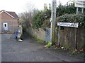
Strawberry Lane
An old lane that predates much of the nineteenth century expansion of the area, it goes down towards the old quarries and clay works of Crews Hole.
Image: © Neil Owen
Taken: 2 Feb 2022
0.04 miles
2
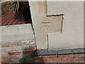
Ordnance Survey Cut Mark
This OS cut mark (Probably a non OS replacement) can be found on No55 Beaconsfield Road. It marked a point 58.967m above mean sea level.
Image: © Adrian Dust
Taken: 1 Aug 2022
0.05 miles
3
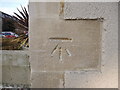
Benchmark on Beaufort Road
The home-owner of the house has spent some time and money on re-rendering the end wall, facing onto Beaufort Road. Thankfully the coin stones and a cutmark have been left as intended. See https://www.bench-marks.org.uk/bm160803 for the entry in the Benchmark Database and Image] for a wider view.
Image: © Neil Owen
Taken: 2 Feb 2022
0.05 miles
4

On the corner of Beaconsfield Road and Beaufort Road
A house at the end of the terrace bears a benchmark - see Image
Image: © Neil Owen
Taken: 2 Feb 2022
0.05 miles
5

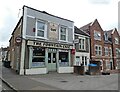
Fountain Cafe, St George
This looks like a nice traditional greasy spoon cafe, on Church Road (the A420). Alas, no time to patronise it. On its left is Beaconsfield Road.
Image: © Derek Harper
Taken: 31 Mar 2012
0.09 miles
7
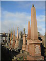
Standing tall in the cemetery
A row of the deceased in Avon View cemetery, each with a tall aspect.
Image: © Neil Owen
Taken: 2 Feb 2022
0.11 miles
8
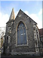
Avon View mortuary chapel
As the expansion of the population of Bristol increased in the nineteenth century but the local churchyards did not follow suit, it became clear that more room for burials was desperately needed. It took the Public Health Act of 1848 to oblige authorities not to overload the existing sites and provide new sites. Avon View opened in 1883 and has expanded its limits on more occasions since. At the centre of the older part is this mortuary chapel, listed initially as Unsectarian.
Image: © Neil Owen
Taken: 2 Feb 2022
0.11 miles
9
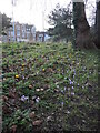
Spring comes to St George's Park
The crocuses break cover.
Image: © Neil Owen
Taken: 2 Feb 2022
0.11 miles
10
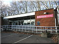
St George library
A modern brick library stands just inside the grounds of St George's Park. It replaces the older Victoria Free library that was here around the turn of the 1900s. An odd stone stump is by the ramp - see Image
Image: © Neil Owen
Taken: 2 Feb 2022
0.11 miles