IMAGES TAKEN NEAR TO
Salisbury Street, BRISTOL, BS5 8EE
Introduction
This page details the photographs taken nearby to Salisbury Street, BS5 8EE by members of the Geograph project.
The Geograph project started in 2005 with the aim of publishing, organising and preserving representative images for every square kilometre of Great Britain, Ireland and the Isle of Man.

There are currently over 7.5m images from over14,400 individuals and you can help contribute to the project by visiting https://www.geograph.org.uk
Image Map
Images are licensed for reuse under creativecommons.org/licenses/by-sa/2.0
Notes
- Clicking on the map will re-center to the selected point.
- The higher the marker number, the further away the image location is from the centre of the postcode.
Image Listing (74 Images Found)
Images are licensed for reuse under creativecommons.org/licenses/by-sa/2.0
Image
Details
Distance
1
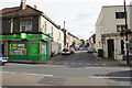
Richmond Road
One of several parallel residential streets off Church Road, the main street through Redfield.
Image: © Bill Boaden
Taken: 28 Sep 2017
0.07 miles
2
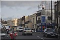
Bristol : Church Lane
Church Lane in Bristol with shops in view such as Smiths Auto Services and BTS Beds.
Image: © Lewis Clarke
Taken: 1 Feb 2013
0.07 miles
3
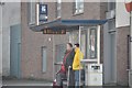
Bristol : Church Lane Bus Stop
Two people waiting for a bus at the stop on Church Lane.
Image: © Lewis Clarke
Taken: 1 Feb 2013
0.08 miles
4
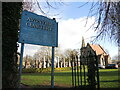
Entrance to Avon View cemetery
An old, hand-painted entrance sign.
Image: © Neil Owen
Taken: 2 Feb 2022
0.09 miles
5
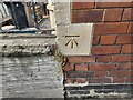
Ordnance Survey Cut Mark
This OS cut mark can be found on No79 Beaufort Road. It marks a point 49.280m above mean sea level.
Image: © Adrian Dust
Taken: 1 Aug 2022
0.09 miles
6
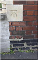
Benchmark on #79 Beaufort Road (Seneca Street face)
Ordnance Survey cut mark benchmark described on the Bench Mark Database at http://www.bench-marks.org.uk/bm80620
Image: © Roger Templeman
Taken: 2 May 2017
0.09 miles
7
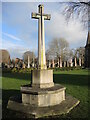
War memorial in Avon View cemetery
The cross and the sword: symbols of past conflicts. This memorial is dedicated to the fallen of WWI - some 85 scattered in the large grounds. At the time, Bristol would have had a number of (often temporary) hospitals to treat the stream of wounded returning from the fronts. There are also the remains of 53 who were lost in WWII, although this monument does not record that fact.
Image: © Neil Owen
Taken: 2 Feb 2022
0.10 miles
8
Houses on Beaufort Road at Seneca Street junction
There is an Ordnance Survey benchmark Image on the bottom stone quoin of the nearest house below the Seneca Street name sign
Image: © Roger Templeman
Taken: 2 May 2017
0.10 miles
9
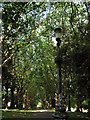
Tree lined avenue in St. George Park
Edwardian lamppost and London Plane trees along the path in St. George Park.
Image: © Duncan Gammon
Taken: 23 Jun 2006
0.10 miles
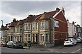
10
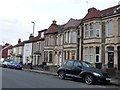
Houses on Beaufort Rd
These houses are opposite the Vale of Avon cemetery in between Seneca St and Cossham Rd. They are mostly substantial stone built terraced houses.
Image: © Nigel Mykura
Taken: 23 Feb 2013
0.10 miles