IMAGES TAKEN NEAR TO
Seneca Street, BRISTOL, BS5 8DX
Introduction
This page details the photographs taken nearby to Seneca Street, BS5 8DX by members of the Geograph project.
The Geograph project started in 2005 with the aim of publishing, organising and preserving representative images for every square kilometre of Great Britain, Ireland and the Isle of Man.

There are currently over 7.5m images from over14,400 individuals and you can help contribute to the project by visiting https://www.geograph.org.uk
Image Map
Images are licensed for reuse under creativecommons.org/licenses/by-sa/2.0
Notes
- Clicking on the map will re-center to the selected point.
- The higher the marker number, the further away the image location is from the centre of the postcode.
Image Listing (84 Images Found)
Images are licensed for reuse under creativecommons.org/licenses/by-sa/2.0
Image
Details
Distance
1
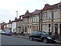
Houses on Beaufort Rd
These houses are opposite the Vale of Avon cemetery in between Seneca St and Cossham Rd. They are mostly substantial stone built terraced houses.
Image: © Nigel Mykura
Taken: 23 Feb 2013
0.06 miles
2
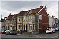
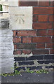
Houses on Beaufort Road at Seneca Street junction
There is an Ordnance Survey benchmark Image on the bottom stone quoin of the nearest house below the Seneca Street name sign
Image: © Roger Templeman
Taken: 2 May 2017
0.06 miles
3
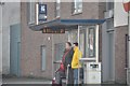
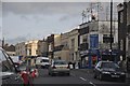
Bristol : Church Lane Bus Stop
Two people waiting for a bus at the stop on Church Lane.
Image: © Lewis Clarke
Taken: 1 Feb 2013
0.06 miles
4
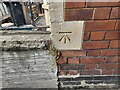
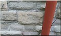
Ordnance Survey Cut Mark
This OS cut mark can be found on No79 Beaufort Road. It marks a point 49.280m above mean sea level.
Image: © Adrian Dust
Taken: 1 Aug 2022
0.06 miles
5
Benchmark on #79 Beaufort Road (Seneca Street face)
Ordnance Survey cut mark benchmark described on the Bench Mark Database at http://www.bench-marks.org.uk/bm80620
Image: © Roger Templeman
Taken: 2 May 2017
0.06 miles
6
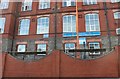
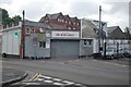
Bristol : Church Lane
Church Lane in Bristol with shops in view such as Smiths Auto Services and BTS Beds.
Image: © Lewis Clarke
Taken: 1 Feb 2013
0.07 miles
8
Ordnance Survey Cut Mark
This OS cut mark can be found on the Nw face of the old St George's School. It marks a point 42.023m above mean sea level.
Image: © Adrian Dust
Taken: 19 Jul 2021
0.09 miles
9
Fire Engine Garage
The Fire Engine Garage, Blackswarth Road, Bristol, Avon - possibly St George's old fire station.
Image: © Kevin Hale
Taken: 26 Jul 2009
0.09 miles
10
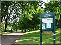
Entrance to St. George Park
St. George Park is a park on the eastern edge of the inner city in Bristol, England.
Image: © Duncan Gammon
Taken: 23 Jun 2006
0.10 miles