IMAGES TAKEN NEAR TO
Church Road, BRISTOL, BS5 8AH
Introduction
This page details the photographs taken nearby to Church Road, BS5 8AH by members of the Geograph project.
The Geograph project started in 2005 with the aim of publishing, organising and preserving representative images for every square kilometre of Great Britain, Ireland and the Isle of Man.

There are currently over 7.5m images from over14,400 individuals and you can help contribute to the project by visiting https://www.geograph.org.uk
Image Map
Images are licensed for reuse under creativecommons.org/licenses/by-sa/2.0
Notes
- Clicking on the map will re-center to the selected point.
- The higher the marker number, the further away the image location is from the centre of the postcode.
Image Listing (80 Images Found)
Images are licensed for reuse under creativecommons.org/licenses/by-sa/2.0
Image
Details
Distance
1
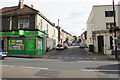
Richmond Road
One of several parallel residential streets off Church Road, the main street through Redfield.
Image: © Bill Boaden
Taken: 28 Sep 2017
0.01 miles
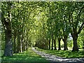
2
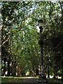
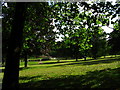
Tree lined avenue in St. George Park
Edwardian lamppost and London Plane trees along the path in St. George Park.
Image: © Duncan Gammon
Taken: 23 Jun 2006
0.03 miles
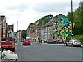
6

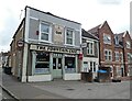
Fountain Cafe, St George
This looks like a nice traditional greasy spoon cafe, on Church Road (the A420). Alas, no time to patronise it. On its left is Beaconsfield Road.
Image: © Derek Harper
Taken: 31 Mar 2012
0.08 miles
7
Early morning in St. George Park
A general view of St. George Park, on the eastern edge of the inner city in Bristol, England. Many old photographs of the park show that it was a popular area in Edwardian times. (As the song says "I was strolling in the park, one day. In the merry, merry month of May!")
There is a banjo shaped lake fed by a natural stream. It has an island, which servers as the nesting place of swans, ducks and moorhens. Until the 1970's, this lake was used for boating, with two separate areas: one for rowing boats and canoes, and the other for small paddle boats, both being available for hire. The lake has since been drained and unsilted, and the boats removed. Now it is used mainly for fishing, and by model boat enthusiasts.
A children's play area, which was modernised several years ago.
Two tennis courts and bowling greens available for hire.
A skate board and cycle activity area with ramps and tumps.
At one time there was a bandstand with wrought iron work, but this was not maintained and was eventually demolished. Fortunately, the site, a raised area, is still there but now has several rose-beds and benches. Band concerts are still held in the park during the summer months, but are now generally played near to and not on the actual bandstand site. (info from wikipedia)
Image: © Duncan Gammon
Taken: 23 Jun 2006
0.08 miles
8
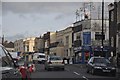
Bristol : Church Lane
Church Lane in Bristol with shops in view such as Smiths Auto Services and BTS Beds.
Image: © Lewis Clarke
Taken: 1 Feb 2013
0.09 miles
9
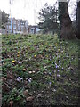
Spring comes to St George's Park
The crocuses break cover.
Image: © Neil Owen
Taken: 2 Feb 2022
0.09 miles
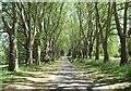
10
Avenue of trees in St George Park
St George Park was originally outside the city boundary of Bristol, and under the control of St George Urban District Council. This avenue of London Plane trees date from 1902.
Image: © Linda Bailey
Taken: 11 Jul 2007
0.10 miles