IMAGES TAKEN NEAR TO
Knapps Lane, BRISTOL, BS5 7UQ
Introduction
This page details the photographs taken nearby to Knapps Lane, BS5 7UQ by members of the Geograph project.
The Geograph project started in 2005 with the aim of publishing, organising and preserving representative images for every square kilometre of Great Britain, Ireland and the Isle of Man.

There are currently over 7.5m images from over14,400 individuals and you can help contribute to the project by visiting https://www.geograph.org.uk
Image Map
Images are licensed for reuse under creativecommons.org/licenses/by-sa/2.0
Notes
- Clicking on the map will re-center to the selected point.
- The higher the marker number, the further away the image location is from the centre of the postcode.
Image Listing (13 Images Found)
Images are licensed for reuse under creativecommons.org/licenses/by-sa/2.0
Image
Details
Distance
1
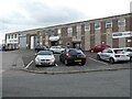
Architectural assortment, Fishponds Trading Estate
Knapps Lane, Fishponds Trading Estate, featuring a variety of industrial architectural styles. Of particular note is the arched building on the left. Although too small to be recognisable, The Dower House at Stoke Park is also in this shot - it's the yellow smudge at the left-hand end of the horizon.
This shot was taken from the back of a lorry while unloading at one of the factories.
Image: © Antony Dixon
Taken: 25 Jan 2012
0.06 miles
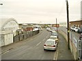
3

Bristol : Rose Green Road
Looking towards Farrantes Foods.
Image: © Lewis Clarke
Taken: 10 Aug 2022
0.11 miles
4
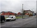
Bristol : Rose Green Road
Looking along Rose Green Road.
Image: © Lewis Clarke
Taken: 10 Aug 2022
0.13 miles
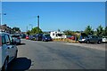
5
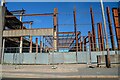
Bristol : Demolition
A demolition seems to be taking place on Deep Pit Road.
Image: © Lewis Clarke
Taken: 10 Aug 2022
0.14 miles
6
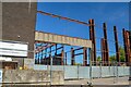
Bristol : Demolition
A demolition seems to be taking place on Deep Pit Road.
Image: © Lewis Clarke
Taken: 10 Aug 2022
0.14 miles
9
New housing in Mallard Close
Infill between Speedwell Road and Whitefield Road.
Image: © Christine Johnstone
Taken: 23 Mar 2013
0.21 miles