IMAGES TAKEN NEAR TO
Ventnor Road, BRISTOL, BS5 7SQ
Introduction
This page details the photographs taken nearby to Ventnor Road, BS5 7SQ by members of the Geograph project.
The Geograph project started in 2005 with the aim of publishing, organising and preserving representative images for every square kilometre of Great Britain, Ireland and the Isle of Man.

There are currently over 7.5m images from over14,400 individuals and you can help contribute to the project by visiting https://www.geograph.org.uk
Image Map
Images are licensed for reuse under creativecommons.org/licenses/by-sa/2.0
Notes
- Clicking on the map will re-center to the selected point.
- The higher the marker number, the further away the image location is from the centre of the postcode.
Image Listing (19 Images Found)
Images are licensed for reuse under creativecommons.org/licenses/by-sa/2.0
Image
Details
Distance
1
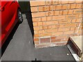
Ordnance Survey Cut Mark
This OS cut mark can be found on No27 Ventnor Road. It marks a point 77.377m above mean sea level.
Image: © Adrian Dust
Taken: 1 Aug 2022
0.03 miles
2
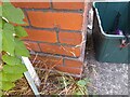
Ordnance Survey Cut Mark
This OS cut mark can be found on No144 Speedwell Road. It marks a point 69.461m above mean sea level.
Image: © Adrian Dust
Taken: 1 Aug 2022
0.13 miles
3
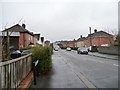
Harewood Road, Speedwell
Looking south from Speedwell Road.
Image: © Christine Johnstone
Taken: 23 Mar 2013
0.13 miles
4
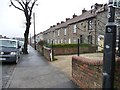
Terraced houses, north side of Speedwell Road
Built of grey stone, like much housing in this area.
Image: © Christine Johnstone
Taken: 23 Mar 2013
0.14 miles
5
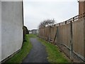
Public footpath to Whitefield Road
Running north from Speedwell Road.
Image: © Christine Johnstone
Taken: 23 Mar 2013
0.14 miles
6
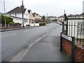
Ventnor Road, BS5
Looking south from the 63 metre spot height on Speedweell Road.
Image: © Christine Johnstone
Taken: 23 Mar 2013
0.14 miles
7
Houses on Whiteway Road, Bristol
Part of an interestingly-staggered terrace on the north side of the road, with the junction with Mill Street on the left.
Image: © Derek Harper
Taken: 31 Mar 2012
0.14 miles
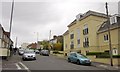
8
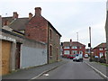
Poplar Road
This is a short residential road in Croft's End that runs from Whitefield Road to Speedwell Road which is visible at the end of the road. The houses in this area are mostly Victorian terraces and inter-war social housing.
Image: © Nigel Mykura
Taken: 23 Feb 2013
0.15 miles
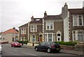
9
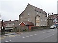
Flats at the junction of Speedwell and Poplar Roads
With quite a baronial appearance. Much of the housing around Crofts End is built of this grey stone.
Image: © Christine Johnstone
Taken: 23 Mar 2013
0.15 miles
10
Whiteway Road, Bristol
The junction with Maldowers Lane. On the right is The Zone, a block of 14 flats completed in 2006.
Image: © Derek Harper
Taken: 31 Mar 2012
0.15 miles