IMAGES TAKEN NEAR TO
Cossham Walk, BRISTOL, BS5 7RH
Introduction
This page details the photographs taken nearby to Cossham Walk, BS5 7RH by members of the Geograph project.
The Geograph project started in 2005 with the aim of publishing, organising and preserving representative images for every square kilometre of Great Britain, Ireland and the Isle of Man.

There are currently over 7.5m images from over14,400 individuals and you can help contribute to the project by visiting https://www.geograph.org.uk
Image Map
Images are licensed for reuse under creativecommons.org/licenses/by-sa/2.0
Notes
- Clicking on the map will re-center to the selected point.
- The higher the marker number, the further away the image location is from the centre of the postcode.
Image Listing (15 Images Found)
Images are licensed for reuse under creativecommons.org/licenses/by-sa/2.0
Image
Details
Distance
1
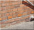
Ordnance Survey Cut Mark
This OS cut mark can be found on No216 Whiteways Road. It marks a point 86.082m above mean sea level.
Image: © Adrian Dust
Taken: 1 Aug 2022
0.08 miles
2
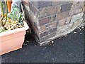
Ordnance Survey Cut Mark
This OS cut mark can be found on No318 Speedwell Road. It marks a point 84.314m above mean sea level.
Image: © Adrian Dust
Taken: 1 Aug 2022
0.09 miles
3

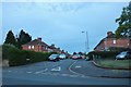
Green Croft, Speedwell
Looking south from Speedwell Road.
Image: © Christine Johnstone
Taken: 23 Mar 2013
0.09 miles
4
Green Croft at the junction of Speedwell Road
Image: © David Howard
Taken: 1 Jun 2019
0.09 miles
5
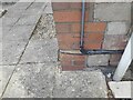
Ordnance Survey Cut Mark
This OS cut mark can be found on No296 Speedwell Road. It marks a point 70.183m above mean sea level.
Image: © Adrian Dust
Taken: 1 Aug 2022
0.10 miles
6
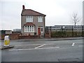
House on Speedwell Road
One half of a pair of semis? With Bristol Brunel Academy behind.
Image: © Christine Johnstone
Taken: 23 Mar 2013
0.11 miles
7
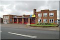
Speedwell Fire Station
Speedwell Fire Station, Speedwell Road, Bristol is station number 11 of Avon Fire & Rescue Service
Image: © Kevin Hale
Taken: 8 May 2006
0.12 miles
8
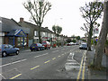
On Speedwell Road, Two Mile Hill, looking west
On Speedwell Road just by its junction with Charlton Road, looking west towards the roundabout-junction
with Whiteway Road. Speedwell Methodist Church is hidden beyond the houses on the left.
Image: © Colin S Pearson
Taken: 23 Oct 2005
0.14 miles
9
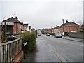
Harewood Road, Speedwell
Looking south from Speedwell Road.
Image: © Christine Johnstone
Taken: 23 Mar 2013
0.15 miles
10

Parade of shops, Sunny Bank, Speedwell
Built in 1929, half empty in 2013.
Image: © Christine Johnstone
Taken: 23 Mar 2013
0.16 miles