IMAGES TAKEN NEAR TO
Park Street, BRISTOL, BS5 7QP
Introduction
This page details the photographs taken nearby to Park Street, BS5 7QP by members of the Geograph project.
The Geograph project started in 2005 with the aim of publishing, organising and preserving representative images for every square kilometre of Great Britain, Ireland and the Isle of Man.

There are currently over 7.5m images from over14,400 individuals and you can help contribute to the project by visiting https://www.geograph.org.uk
Image Map
Images are licensed for reuse under creativecommons.org/licenses/by-sa/2.0
Notes
- Clicking on the map will re-center to the selected point.
- The higher the marker number, the further away the image location is from the centre of the postcode.
Image Listing (17 Images Found)
Images are licensed for reuse under creativecommons.org/licenses/by-sa/2.0
Image
Details
Distance
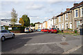
1
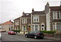
Houses on Whiteway Road, Bristol
Part of an interestingly-staggered terrace on the north side of the road, with the junction with Mill Street on the left.
Image: © Derek Harper
Taken: 31 Mar 2012
0.05 miles
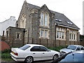
2
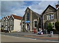
St. George, former church
On Bell Hill Road; shown on old OS maps as a Methodist church; later, glaziers, now up for sale.
Image: © Mike Faherty
Taken: 19 Jul 2011
0.07 miles
3
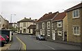
Whiteway Road, Bristol
The cream building on the corner of Clouds Hill Road is the World's End pub. On this side of the pub is the junction with Hudd's Vale Road. On the extreme right is a new house.
Image: © Derek Harper
Taken: 31 Mar 2012
0.08 miles
4
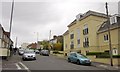
Whiteway Road, Bristol
The junction with Maldowers Lane. On the right is The Zone, a block of 14 flats completed in 2006.
Image: © Derek Harper
Taken: 31 Mar 2012
0.08 miles
5
Old Chapel in Kensing Road
Marked on the map as a church, but it seems to be a public hall now.
Image: © William Avery
Taken: 18 Sep 2006
0.16 miles
6
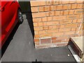
Ordnance Survey Cut Mark
This OS cut mark can be found on No27 Ventnor Road. It marks a point 77.377m above mean sea level.
Image: © Adrian Dust
Taken: 1 Aug 2022
0.17 miles
7
Mechanics' Arms, Clouds Hill Road
Part of a curving terrace on the A420. http://bristolslostpubs.eu/page137.html suggests it was first licensed in 1883.
Image: © Derek Harper
Taken: 31 Mar 2012
0.19 miles
8
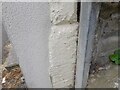
Ordnance Survey Cut Mark
This OS cut mark can be found on No82 Clouds Hill Road. It marks a point 64.368m above mean sea level.
Image: © Adrian Dust
Taken: 1 Aug 2022
0.20 miles
9
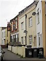
Bethel Road
One of the typically quite colourful residential streets of Bristol, though parking is often a challenge.
Image: © Bill Boaden
Taken: 28 Sep 2017
0.20 miles
10
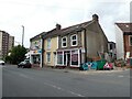
'Brizzle Born Bakery', St George
Bought a lovely corned beef pasty here. Highly recommended!
Image: © Roger Cornfoot
Taken: 7 Jun 2021
0.21 miles