IMAGES TAKEN NEAR TO
Hillside Road, BRISTOL, BS5 7PF
Introduction
This page details the photographs taken nearby to Hillside Road, BS5 7PF by members of the Geograph project.
The Geograph project started in 2005 with the aim of publishing, organising and preserving representative images for every square kilometre of Great Britain, Ireland and the Isle of Man.

There are currently over 7.5m images from over14,400 individuals and you can help contribute to the project by visiting https://www.geograph.org.uk
Image Map
Images are licensed for reuse under creativecommons.org/licenses/by-sa/2.0
Notes
- Clicking on the map will re-center to the selected point.
- The higher the marker number, the further away the image location is from the centre of the postcode.
Image Listing (11 Images Found)
Images are licensed for reuse under creativecommons.org/licenses/by-sa/2.0
Image
Details
Distance
1
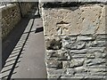
Ordnance Survey Cut Mark
This OS cut mark can be found on the SE angle of the school on Hillside Road. It marks a point 78.200m above mean sea level.
Image: © Adrian Dust
Taken: 1 Aug 2022
0.06 miles
2
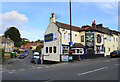
The Lord Raglan
A pub at the meeting of Nags Head Hill and Stibbs Hill.
Image: © Bill Boaden
Taken: 28 Sep 2017
0.10 miles
4
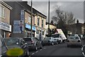
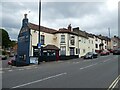
Bristol : Nags Head Hill
The Road heads up the hill - and Where's Wally?
Image: © Lewis Clarke
Taken: 1 Feb 2013
0.12 miles
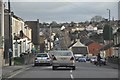
6
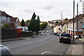
Nags Head Hill
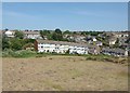
Showing some of the gradients in the eastern suburbs of Bristol.
Image: © Bill Boaden
Taken: 28 Sep 2017
0.12 miles
7
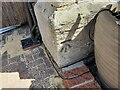
Ordnance Survey Cut Mark
This OS cut mark can be found on the old chapel NE side of Air Balloon Road. It marks a point 69.610m above mean sea level.
Image: © Adrian Dust
Taken: 1 Aug 2022
0.13 miles
8
Bristol : Air Balloon Road
An interesting name for a road which heads down the hill.
Image: © Lewis Clarke
Taken: 1 Feb 2013
0.15 miles
9
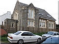
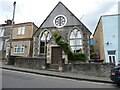
Old Chapel in Kensing Road
Marked on the map as a church, but it seems to be a public hall now.
Image: © William Avery
Taken: 18 Sep 2006
0.20 miles