IMAGES TAKEN NEAR TO
Marling Road, BRISTOL, BS5 7LP
Introduction
This page details the photographs taken nearby to Marling Road, BS5 7LP by members of the Geograph project.
The Geograph project started in 2005 with the aim of publishing, organising and preserving representative images for every square kilometre of Great Britain, Ireland and the Isle of Man.

There are currently over 7.5m images from over14,400 individuals and you can help contribute to the project by visiting https://www.geograph.org.uk
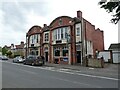
Image Map
Images are licensed for reuse under creativecommons.org/licenses/by-sa/2.0
Notes
- Clicking on the map will re-center to the selected point.
- The higher the marker number, the further away the image location is from the centre of the postcode.
Image Listing (22 Images Found)
Images are licensed for reuse under creativecommons.org/licenses/by-sa/2.0
Image
Details
Distance
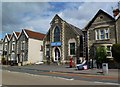
1
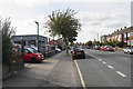
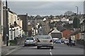
Summerhill Road
Part of the A431 passing through mostly residential housing.
Image: © Bill Boaden
Taken: 28 Sep 2017
0.09 miles
2
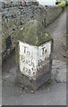
Old Milestone by the A431, Summerhill Road, Bristol
Metal plates attached to stone post by the A431, in parish of Bristol (City of Bristol District), by No. 126 Summerhill Road, St George, junction with a footpath to allotments, on South side of road. Erected by the Bristol turnpike trust in the 19th century.
Inscription reads:-
: To / Bath / 9½ : : To / Briftol / 2 :
Carved benchmark on right side, lower face.
Grade II listed.
List Entry Number: 1209012 https://historicengland.org.uk/listing/the-list/list-entry/1209012
Milestone Society National ID: GL_BRBA02
Image: © M Faherty
Taken: 19 Jul 2011
0.10 miles
3
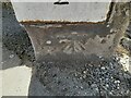
Ordnance Survey Cut Mark
This OS cut mark can be found on the milestone SW side of Summerhill Road. It marks a point 127.752m above mean sea level.
Image: © Adrian Dust
Taken: 1 Aug 2022
0.10 miles
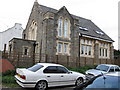
4
St. George, former church
On Bell Hill Road; shown on old OS maps as a Methodist church; later, glaziers, now up for sale.
Image: © Mike Faherty
Taken: 19 Jul 2011
0.11 miles
5
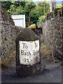
Milestone by Summerhill Road
This milestone is beside Summerhill Road. It says its 9.5 miles to Bath and 2 miles to Briftol (well the old fashioned 's'). The footpath heads down the hill towards allotments.
Image: © Linda Bailey
Taken: 9 Jul 2007
0.11 miles
6
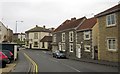
Whiteway Road, Bristol
The cream building on the corner of Clouds Hill Road is the World's End pub. On this side of the pub is the junction with Hudd's Vale Road. On the extreme right is a new house.
Image: © Derek Harper
Taken: 31 Mar 2012
0.13 miles
7
Old Chapel in Kensing Road
Marked on the map as a church, but it seems to be a public hall now.
Image: © William Avery
Taken: 18 Sep 2006
0.14 miles
8
Bristol : Air Balloon Road
An interesting name for a road which heads down the hill.
Image: © Lewis Clarke
Taken: 1 Feb 2013
0.14 miles
9
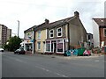
'Brizzle Born Bakery', St George
Bought a lovely corned beef pasty here. Highly recommended!
Image: © Roger Cornfoot
Taken: 7 Jun 2021
0.14 miles