IMAGES TAKEN NEAR TO
Gordon Avenue, BRISTOL, BS5 7DS
Introduction
This page details the photographs taken nearby to Gordon Avenue, BS5 7DS by members of the Geograph project.
The Geograph project started in 2005 with the aim of publishing, organising and preserving representative images for every square kilometre of Great Britain, Ireland and the Isle of Man.

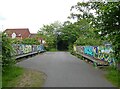
There are currently over 7.5m images from over14,400 individuals and you can help contribute to the project by visiting https://www.geograph.org.uk
Image Map
Images are licensed for reuse under creativecommons.org/licenses/by-sa/2.0
Notes
- Clicking on the map will re-center to the selected point.
- The higher the marker number, the further away the image location is from the centre of the postcode.
Image Listing (63 Images Found)
Images are licensed for reuse under creativecommons.org/licenses/by-sa/2.0
Image
Details
Distance
1
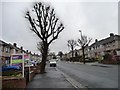
Trimmed trees in Gordon Avenue
A way of making old trees not grow any bigger.
Image: © Christine Johnstone
Taken: 23 Mar 2013
0.02 miles
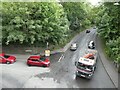
2
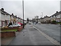
Gordon Avenue, Rose Green
All quiet on a cold and damp Saturday morning.
Image: © Christine Johnstone
Taken: 23 Mar 2013
0.05 miles
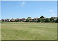
3
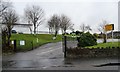
The Rose Green Centre
Home to the Bristol West Indian Cricket Club.
Image: © Christine Johnstone
Taken: 23 Mar 2013
0.06 miles
4
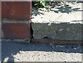
Ordnance Survey Pivot
This OS pivot can be found on the step of No117 Gordon Road. It marks a point 46.107m above mean sea level.
Image: © Adrian Dust
Taken: 19 Jul 2021
0.11 miles
5
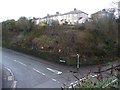
Houses in Stanley Chase
Seen from the Bristol and Bath Railway Path.
Image: © Christine Johnstone
Taken: 23 Mar 2013
0.16 miles
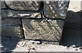
6
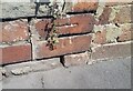
Ordnance Survey Cut Mark
This OS cut mark can be found on the wall of No451 Whitehall Road. It marks a point 58.345m above mean sea level.
Image: © Adrian Dust
Taken: 19 Jul 2021
0.16 miles
10
Ordnance Survey Cut Mark
This OS cut mark can be found on the wall SW side of Gordon Road. It marks a point 36.515m above mean sea level.
Image: © Adrian Dust
Taken: 19 Jul 2021
0.18 miles