IMAGES TAKEN NEAR TO
Park Crescent, BRISTOL, BS5 7AT
Introduction
This page details the photographs taken nearby to Park Crescent, BS5 7AT by members of the Geograph project.
The Geograph project started in 2005 with the aim of publishing, organising and preserving representative images for every square kilometre of Great Britain, Ireland and the Isle of Man.

There are currently over 7.5m images from over14,400 individuals and you can help contribute to the project by visiting https://www.geograph.org.uk
Image Map
Images are licensed for reuse under creativecommons.org/licenses/by-sa/2.0
Notes
- Clicking on the map will re-center to the selected point.
- The higher the marker number, the further away the image location is from the centre of the postcode.
Image Listing (57 Images Found)
Images are licensed for reuse under creativecommons.org/licenses/by-sa/2.0
Image
Details
Distance
1

Ordnance Survey Cut Mark
This OS cut mark can be found on the wall junction of Nos. 23 & 24 Park Crescent. It marks a point 48.719m above mean sea level.
Image: © Adrian Dust
Taken: 19 Jul 2021
0.02 miles
2
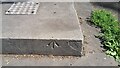
Ordnance Survey Rivet
This OS rivet can be found on the concrete base of the now missing Water Fountain. It marks a point 42.913m above mean sea level.
Image: © Adrian Dust
Taken: 19 Jul 2021
0.06 miles
4
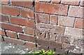
Ordnance Survey Cut Mark
This OS cut mark can be found on the building at the rear of No47 Park Crescent. It marks a point 51.307m above mean sea level.
Image: © Adrian Dust
Taken: 19 Jul 2021
0.09 miles
5

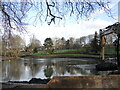
Duck pond in St. George Park
View showing the duck pond and fountain in St. George Park, Bristol
Image: © Duncan Gammon
Taken: 23 Jun 2006
0.09 miles
6
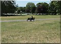
St George's Park
This is the Howard Street end of the park.
The autumnal appearance is due to the drought and hot temperatures endured in the summer of 2022.
Image: © Jonathan Billinger
Taken: 20 Aug 2022
0.10 miles
7
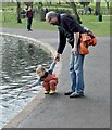
Testing the water
St George Park, Bristol
Image: © Anthony O'Neil
Taken: 15 Feb 2021
0.10 miles
8

Howard Street, Whitehall
Residential area to the east of Bristol city centre.
Image: © Jonathan Billinger
Taken: 20 Aug 2022
0.10 miles
9
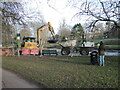
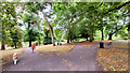
Watching, waiting, for the reopening
St George's Park is having some much-needed work carried out. Bristol City council has set aside £400,000 and six months for urgent repairs and upgrading to take place around the lake. Silting, subsidence and the desire to create new and better wildlife habitats has demanded this extensive approach. New paths are due to allow access to the wildlife and enable people to take a greater interest in the natural environment.
Image: © Neil Owen
Taken: 2 Feb 2022
0.10 miles
10
Redirecting the wildlife
St George's Park lake is being given a major refurbishment. Silt is beign gathered up and redistributed to create wetland areas to allow a more diverse environment. New paths will allow access to different types of habitat and the work is expected to take six months.
Image: © Neil Owen
Taken: 2 Feb 2022
0.10 miles