IMAGES TAKEN NEAR TO
Foxcroft Road, BRISTOL, BS5 7AH
Introduction
This page details the photographs taken nearby to Foxcroft Road, BS5 7AH by members of the Geograph project.
The Geograph project started in 2005 with the aim of publishing, organising and preserving representative images for every square kilometre of Great Britain, Ireland and the Isle of Man.

There are currently over 7.5m images from over14,400 individuals and you can help contribute to the project by visiting https://www.geograph.org.uk
Image Map
Images are licensed for reuse under creativecommons.org/licenses/by-sa/2.0
Notes
- Clicking on the map will re-center to the selected point.
- The higher the marker number, the further away the image location is from the centre of the postcode.
Image Listing (58 Images Found)
Images are licensed for reuse under creativecommons.org/licenses/by-sa/2.0
Image
Details
Distance
1
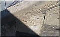
Ordnance Survey Cut Mark
This OS cut mark can be found on the steps of the Chapel, Whitehall Road. It marks a point 38.033m above mean sea level.
Image: © Adrian Dust
Taken: 19 Jul 2021
0.05 miles
2
The old hall in Stretford Road
The original building of St Ambrose was founded in 1905, with a mission hall that could accommodate 300 people and held two classrooms. However, this proved inadequate and so a newer, bigger church was built in 1912-13. The old hall still serves the community.
Image: © Neil Owen
Taken: 2 Feb 2022
0.07 miles
5
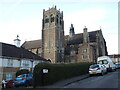
The west window of St Ambrose
The east window is a large and imposing feature of the church, but the east is not unworthy.
Image: © Neil Owen
Taken: 2 Feb 2022
0.08 miles
8
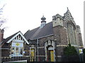
Rising above the parish of Whitehall
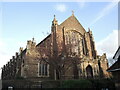
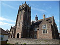
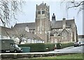
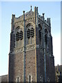
St Ambrose's church is a large and imposing sight, rising above St George's Park and dominating the local landscape. It is a fairly new church: in the late nineteenth century moves were made to gather some of the expanding suburban population. In 1905 a smaller hall and mission church was established (see Image]) but this became too small shortly thereafter. With funds raised a new church was established, with the foundation stone dated 1912 and the consecration taking place on November 13th, 1913.
The architects were W.V. and A.R. Gough, who chose to use a mixture of Perpendicular and Arts and Crafts styles. The tower has a grand and unusual appearance, with embattled turrets and stepped battlemented parapets; it is also unusual in that it is sited to the south-east of the south aisle. See Image
To the left of shot are the modern flats that are the St John's almshouses. The original almshouses were part of St John-on-the-Wall in the city centre, but moved to this place in 1906.
Image: © Neil Owen
Taken: 2 Feb 2022
0.10 miles
9
High above Stretford Road
The tower of St Ambrose dominates. See Image] for a contextual view.
Image: © Neil Owen
Taken: 2 Feb 2022
0.10 miles
10
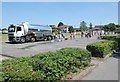
... and not a drop to drink!
Local householders form a queue, rescued from a mains leak by a Bristol Water tanker.
Image: © Anthony O'Neil
Taken: 30 May 2020
0.10 miles