IMAGES TAKEN NEAR TO
Cottrell Road, BRISTOL, BS5 6TL
Introduction
This page details the photographs taken nearby to Cottrell Road, BS5 6TL by members of the Geograph project.
The Geograph project started in 2005 with the aim of publishing, organising and preserving representative images for every square kilometre of Great Britain, Ireland and the Isle of Man.

There are currently over 7.5m images from over14,400 individuals and you can help contribute to the project by visiting https://www.geograph.org.uk
Image Map
Images are licensed for reuse under creativecommons.org/licenses/by-sa/2.0
Notes
- Clicking on the map will re-center to the selected point.
- The higher the marker number, the further away the image location is from the centre of the postcode.
Image Listing (44 Images Found)
Images are licensed for reuse under creativecommons.org/licenses/by-sa/2.0
Image
Details
Distance
2
Raja Rammohun Roy Walk
Raja Ram Mohun Roy is considered the Father of Modern India. He came to Britain in 1831 as an ambassador of the Mughal Empire and died in Stapleton of meningitis in 1833. He is buried in a mausoleum in Arnos Vale Cemetery, and there is a statue of him in College Green Image https://en.wikipedia.org/wiki/Ram_Mohan_Roy
Image: © Eirian Evans
Taken: 19 Feb 2018
0.04 miles
3
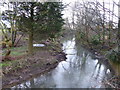
River Frome
Rising in Dodington near Chipping Sodbury, the river Frome to join the Avon at the Floating Harbour.
Image: © Eirian Evans
Taken: 19 Feb 2018
0.05 miles
4
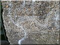
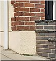
Ordnance Survey Cut Mark
This OS cut mark can be found on the wall SE side of Glenfrome Road. It marks a point 13.518m above mean sea level.
Image: © Adrian Dust
Taken: 27 Jul 2022
0.06 miles
5
Ordnance Survey Cut Mark
This OS cut mark can be found on No269 Glenfrome Road. It marks a point 15.520m above mean sea level.
Image: © Adrian Dust
Taken: 27 Jul 2022
0.07 miles
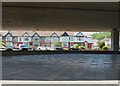
7

Bridge within a bridge
M32 and Stapleton Road crossing the River Frome at Eastville
Image: © Anthony O'Neil
Taken: 31 May 2020
0.08 miles
8
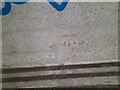
Ordnance Survey Cut Mark
This OS cut mark can be found on the SE parapet of Stapleton Bridge. It marks a point 13.314m above mean sea level.
Image: © Adrian Dust
Taken: 27 Jul 2022
0.08 miles
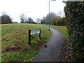
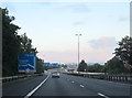
9
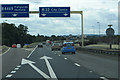
Take your pick
The road to Fishponds leaves the M32.
Image: © Robert Ashby
Taken: 16 Aug 2014
0.08 miles
10
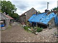
Buildings at the entrance to the Bridge Farm Community site, Eastville
Image: © David Gearing
Taken: 25 Jul 2022
0.08 miles