IMAGES TAKEN NEAR TO
Stapleton Road, BRISTOL, BS5 6NA
Introduction
This page details the photographs taken nearby to Stapleton Road, BS5 6NA by members of the Geograph project.
The Geograph project started in 2005 with the aim of publishing, organising and preserving representative images for every square kilometre of Great Britain, Ireland and the Isle of Man.

There are currently over 7.5m images from over14,400 individuals and you can help contribute to the project by visiting https://www.geograph.org.uk
Image Map
Images are licensed for reuse under creativecommons.org/licenses/by-sa/2.0
Notes
- Clicking on the map will re-center to the selected point.
- The higher the marker number, the further away the image location is from the centre of the postcode.
Image Listing (106 Images Found)
Images are licensed for reuse under creativecommons.org/licenses/by-sa/2.0
Image
Details
Distance
1
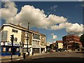
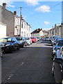
Junction on Stapleton Road
The traffic is waiting at the lights to turn out of the B4058, Stapleton Road. The A432, which is Stapleton Road to the left past the row of shops, continues to the right as Fishponds Road. The brick building on the right is Ashbourne House, offices.
Image: © Derek Harper
Taken: 7 Sep 2013
0.04 miles
2
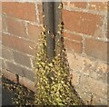
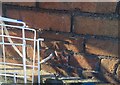
Ordnance Survey Cut Mark
This OS cut mark can be found on No417 Stapleton Road. It marks a point 12.661m above mean sea level.
Image: © Adrian Dust
Taken: 19 Jul 2021
0.04 miles
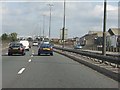
4
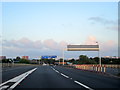
M32 Bristol Approaching Junction For Bath
Image: © Roy Hughes
Taken: 27 Jun 2015
0.06 miles
5
Zhyan Restaurant, Easton, Bristol
At 404 Stapleton Road, between Bikkle Island Caribbean fast food and the African Village Barbecue.
Image: © Jaggery
Taken: 13 Sep 2018
0.08 miles
6
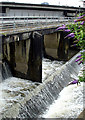
Weir on River Frome
This weir is just below the M32 going into Bristol (top of the photo shows a car on the M32). This is the River Frome which goes underground shortly after this point.
Image: © Linda Bailey
Taken: 1 Jul 2007
0.08 miles
7
Ordnance Survey Cut Mark
This OS cut mark can be found on No112 St Marks Road. It marks a point 14.246m above mean sea level.
Image: © Adrian Dust
Taken: 19 Jul 2021
0.08 miles

9
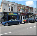
Nowhere left to park in Clare Road, Easton, Bristol
Viewed from the corner of Stapleton Road at 2:40pm on Thursday September 13th 2018.
A June 2014 Google Earth Street View shows a similar scene dominated by parked cars.
Image: © Jaggery
Taken: 13 Sep 2018
0.10 miles
10
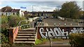
Footbridge on the edge of Ikea land
Access to Stapleton Road from the Ikea car park with the elevated M32 seen beyond.
Image: © Jonathan Billinger
Taken: 3 Nov 2018
0.10 miles