IMAGES TAKEN NEAR TO
Carlyle Road, BRISTOL, BS5 6HG
Introduction
This page details the photographs taken nearby to Carlyle Road, BS5 6HG by members of the Geograph project.
The Geograph project started in 2005 with the aim of publishing, organising and preserving representative images for every square kilometre of Great Britain, Ireland and the Isle of Man.

There are currently over 7.5m images from over14,400 individuals and you can help contribute to the project by visiting https://www.geograph.org.uk
Image Map
Images are licensed for reuse under creativecommons.org/licenses/by-sa/2.0
Notes
- Clicking on the map will re-center to the selected point.
- The higher the marker number, the further away the image location is from the centre of the postcode.
Image Listing (63 Images Found)
Images are licensed for reuse under creativecommons.org/licenses/by-sa/2.0
Image
Details
Distance
1
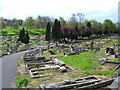
Greenbank Cemetery
Greenbank Cemetery taken from Greenbank View, Bristol
Image: © Kate Lambert
Taken: 19 Apr 2005
0.04 miles
2
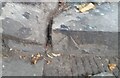
Ordnance Survey Pivot
This OS pivot can be found on the step at the entrance to the cemetery on Greenbank Road. It marks a point 33.644m above mean sea level.
Image: © Adrian Dust
Taken: 19 Jul 2021
0.04 miles
3
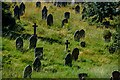
Bristol : Greenbank Cemetery
Looking across towards headstones on the hillside.
Image: © Lewis Clarke
Taken: 10 Aug 2022
0.08 miles
4
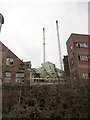
Packers chocolate factory, Bristol
A view from the Bristol & Bath Railway Path. The factory was built at the beginning of the C20 http://www.cems.uwe.ac.uk/~rstephen/livingeaston/local_history/packers.html .
Image: © Derek Harper
Taken: 31 Mar 2012
0.09 miles
5
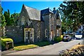
Bristol : Greenbank Cemetery Lodge
A lodge in Greenbank Cemetery.
Image: © Lewis Clarke
Taken: 10 Aug 2022
0.10 miles
6
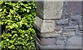
Ordnance Survey Cut Mark
This OS cut mark can be found on the Lodge at Greenbank Cemetery. It marks a point 27.728m above mean sea level.
Image: © Adrian Dust
Taken: 19 Jul 2021
0.10 miles
7
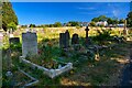
Bristol : Greenbank Cemetery
Looking across the grounds of the cemetery.
Image: © Lewis Clarke
Taken: 10 Aug 2022
0.10 miles
8
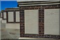
Bristol : Greenbank Cemetery
Close to the entrance is the first of Greenbank’s war memorials. A sequence of brick walls set with carved slabs commemorates those who died ‘in service to their country’ in both WWI and WWII and are buried elsewhere in the cemetery.
Image: © Lewis Clarke
Taken: 10 Aug 2022
0.11 miles
10
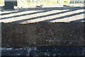
Ordnance Survey Pivot
This OS pivot can be found on the cemetery wall NE side of Thurlow Road. It marks a point 27.450m above mean sea level.
Image: © Adrian Dust
Taken: 19 Jul 2021
0.11 miles