IMAGES TAKEN NEAR TO
Greenbank Avenue West, BRISTOL, BS5 6EP
Introduction
This page details the photographs taken nearby to Greenbank Avenue West, BS5 6EP by members of the Geograph project.
The Geograph project started in 2005 with the aim of publishing, organising and preserving representative images for every square kilometre of Great Britain, Ireland and the Isle of Man.

There are currently over 7.5m images from over14,400 individuals and you can help contribute to the project by visiting https://www.geograph.org.uk
Image Map
Images are licensed for reuse under creativecommons.org/licenses/by-sa/2.0
Notes
- Clicking on the map will re-center to the selected point.
- The higher the marker number, the further away the image location is from the centre of the postcode.
Image Listing (86 Images Found)
Images are licensed for reuse under creativecommons.org/licenses/by-sa/2.0
Image
Details
Distance
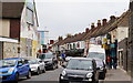
1
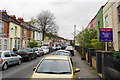
High Street, Easton
Not a traditional high street, but a typically tightly packed residential street.
Image: © Bill Boaden
Taken: 14 Apr 2017
0.05 miles
2
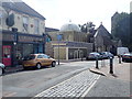
Easton Jamia Masjid mosque
The Easton Mosque as it is commonly known is situated in an old Church hall near the shops in St Marks Road. It is one of the larger Mosques in Bristol holding up to 600 people.
Image: © Eirian Evans
Taken: 31 Aug 2018
0.08 miles
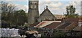
3
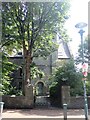
St Mark's Church House
Now converted into housing for people who need supported care.
Image: © Eirian Evans
Taken: 31 Aug 2018
0.09 miles
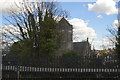
4
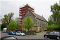
St Mark's Church, Easton
Famous for its tower which is shrouded in scaffolding. It has been closed as a church, but the building is now part of a housing scheme.
Image: © Bill Boaden
Taken: 14 Apr 2017
0.09 miles
5
St Mark's Road
A focus for the local community with food outlets and shops.
Image: © Bill Boaden
Taken: 14 Apr 2017
0.09 miles
8
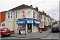
Belle Vue News
A typical corner shop on the corner of Tudor Road and Belle Vue Road.
Image: © Bill Boaden
Taken: 14 Apr 2017
0.10 miles
9
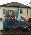
Mural, Anstey Street, Bristol
This tentacular creation is by the junction with Roman Road. It's bucketing.
Image: © Derek Harper
Taken: 19 Oct 2017
0.10 miles
10
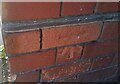
Ordnance Survey Cut Mark
This OS cut mark can be found on the NW angle of the Gym (Former Works) on Roman Road. It marks a point 13.689m above mean sea level.
Image: © Adrian Dust
Taken: 19 Jul 2021
0.11 miles