IMAGES TAKEN NEAR TO
Chelsea Road, BRISTOL, BS5 6AR
Introduction
This page details the photographs taken nearby to Chelsea Road, BS5 6AR by members of the Geograph project.
The Geograph project started in 2005 with the aim of publishing, organising and preserving representative images for every square kilometre of Great Britain, Ireland and the Isle of Man.

There are currently over 7.5m images from over14,400 individuals and you can help contribute to the project by visiting https://www.geograph.org.uk
Image Map
Images are licensed for reuse under creativecommons.org/licenses/by-sa/2.0
Notes
- Clicking on the map will re-center to the selected point.
- The higher the marker number, the further away the image location is from the centre of the postcode.
Image Listing (46 Images Found)
Images are licensed for reuse under creativecommons.org/licenses/by-sa/2.0
Image
Details
Distance
2
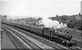
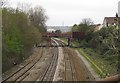
Empty stock train approaching Lawrence Hill, running Down towards Bristol
View northward, towards Stapleton Road, Filton Junction, then South Wales via the Severn Tunnel, to Gloucester and the North, also eastward via Badminton to Swindon and London: ex-GWR main lines. The locomotive is Collett 4-6-0 No. 5963 'Wimpole Hall' (built 7/36, withdrawn 6/64).
Image: © Ben Brooksbank
Taken: 11 Aug 1962
0.07 miles
3
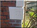
Ordnance Survey Cut Mark
This OS cut mark can be found on No27 All Hallows Road. It marks a point 20.861m above mean sea level.
Image: © Adrian Dust
Taken: 19 Jul 2021
0.08 miles
4
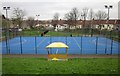
Games Court, Easton
This multi use games court is in the Owen Square Play Park http://www.goplacestoplay.org.uk/pathfinder_sites/23-owen-square-park ; seen from the Bristol & Bath Railway Path.
Image: © Derek Harper
Taken: 31 Mar 2012
0.08 miles
5
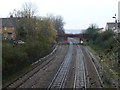
Railway line, Easton
Taken from the Bristol & Bath Railway cyclepath looking towards the Easton Road bridge; a reverse view of Image taken nearly 50 years earlier. This is the main line between Lawrence Hill and Stapleton Road stations.
Image: © Derek Harper
Taken: 31 Mar 2012
0.10 miles
6
Looking north towards Easton Road bridge
Seen from the Bristol and Bath Railway Path.
Image: © Christine Johnstone
Taken: 23 Mar 2013
0.10 miles
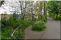
7
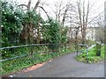
Footpath to Whitehall Road
Most of the paths off the Bristol and Bath Railway Path are signposted by these ground-level signs like railway totems.
Image: © Christine Johnstone
Taken: 23 Mar 2013
0.10 miles
8
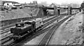
Engine-&-brake from Bristol making for Stapleton Road etc. north of Lawrence Hill
View southward, towards Lawrence Hill, Dr. Day's Bridge Junction and Bristol: ex-GW main lines out of Bristol. (For detail see Image] and other views here). The engine is Collett '5700' class 0-6-0PT No. 8746 (built 7/31, withdrawn 12/62). The bridge crossing carries the ex-Midland main line to Birmingham via Mangotsfield.
Image: © Ben Brooksbank
Taken: 11 Aug 1962
0.11 miles
9
Bristol and Bath Railway Path by Whitehall Road
A cycle route on a former railway, now nearing Bristol.
Image: © Bill Boaden
Taken: 14 Apr 2017
0.11 miles
10
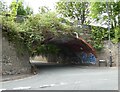
Former railway bridge, over Easton Road
Image: © Roger Cornfoot
Taken: 7 Jun 2021
0.11 miles