IMAGES TAKEN NEAR TO
Pountney Drive, BRISTOL, BS5 0XG
Introduction
This page details the photographs taken nearby to Pountney Drive, BS5 0XG by members of the Geograph project.
The Geograph project started in 2005 with the aim of publishing, organising and preserving representative images for every square kilometre of Great Britain, Ireland and the Isle of Man.

There are currently over 7.5m images from over14,400 individuals and you can help contribute to the project by visiting https://www.geograph.org.uk
Image Map
Images are licensed for reuse under creativecommons.org/licenses/by-sa/2.0
Notes
- Clicking on the map will re-center to the selected point.
- The higher the marker number, the further away the image location is from the centre of the postcode.
Image Listing (29 Images Found)
Images are licensed for reuse under creativecommons.org/licenses/by-sa/2.0
Image
Details
Distance
1
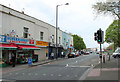
2011 : Shops in Stapleton Road, Bristol
On the A432 heading out of Bristol via Fishponds and Downend eventually to Old Sodbury.
The shop fronts give a clue to the ethnic mix of the area.
Image: © Maurice Pullin
Taken: 17 Apr 2011
0.12 miles
2
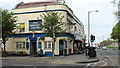
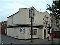
2011 : The Armoury Tavern, Easton, Bristol
http://www.britishpubguide.com/cgi-bin/pub.cgi?results:Bristol:195 Says "The Armoury is a lively street corner local, brightly painted on the outside. Inside, there is an L-shaped, tidily furnished drinking area with oak beams on the ceiling, carpeting throughout and wooden seating dotted about the place. At the rear is the pool table, and there are bench seats outside for that al fresco experience." Not spit and sawdust then as remembered from the 1950's.
Image: © Maurice Pullin
Taken: 17 Apr 2011
0.14 miles
4
The Armoury Tavern and a row of shops
Situated on Stapleton Road at the end of Armoury Square.
Image: © Bill Boaden
Taken: 14 Apr 2017
0.14 miles
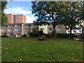
5
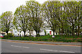
Rawnsley Park
Viewed from the other side of Stapleton Road, with the houses of Beaumont Street to the left.
Image: © Bill Boaden
Taken: 14 Apr 2017
0.14 miles
6
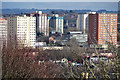
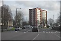
Bristol : City Scenery
Looking across the city scenery with apartment blocks in view.
Image: © Lewis Clarke
Taken: 24 Mar 2015
0.15 miles
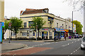
7
The Chelsea Pub, Easton Bristol
Good ale in a very mixed urban area
Image: © John Phillips
Taken: 6 Sep 2003
0.15 miles
8
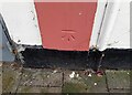
Ordnance Survey Cut Mark
This OS cut mark can be found on No128 Stapleton Road. It marks a point 14.402m above mean sea level.
Image: © Adrian Dust
Taken: 3 Jul 2024
0.15 miles
9
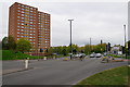
Bristol : Lawrence Hill
Lawrence Hill with a block of flats known as Baynton House in view.
Image: © Lewis Clarke
Taken: 1 Feb 2013
0.15 miles
10
Easton Way
A bit of a ring road round the eastern side of Bristol.
Image: © Bill Boaden
Taken: 14 Apr 2017
0.15 miles