IMAGES TAKEN NEAR TO
Blenheim Street, BRISTOL, BS5 0NF
Introduction
This page details the photographs taken nearby to Blenheim Street, BS5 0NF by members of the Geograph project.
The Geograph project started in 2005 with the aim of publishing, organising and preserving representative images for every square kilometre of Great Britain, Ireland and the Isle of Man.

There are currently over 7.5m images from over14,400 individuals and you can help contribute to the project by visiting https://www.geograph.org.uk
Image Map
Images are licensed for reuse under creativecommons.org/licenses/by-sa/2.0
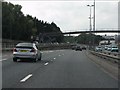
Notes
- Clicking on the map will re-center to the selected point.
- The higher the marker number, the further away the image location is from the centre of the postcode.
Image Listing (103 Images Found)
Images are licensed for reuse under creativecommons.org/licenses/by-sa/2.0
Image
Details
Distance
1
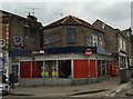
Tollhouse by Stapleton Road, Bristol
Tollhouse in the parish of Bristol (City of Bristol District), Toll House, No. 250 (Betting shop), Stapleton Road, on corner of Oxford Place.
Surveyed
Milestone Society National ID: AV.BRI03
Image: © Milestone Society
Taken: Unknown
0.06 miles
2
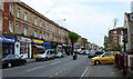
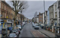
2011 : A432 Stapleton Road, Bristol
Heading out of Bristol toward Eastville and Downend.
A closer look at the shop fronts reveals the ethnic mix of the area, and the varied interests.
Image: © Maurice Pullin
Taken: 17 Apr 2011
0.07 miles
3
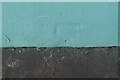
Ordnance Survey Cut Mark
This covered and almost lost OS cut mark can be found on No269 Stapleton Road. It marked a point 17.017m above mean sea level.
Image: © Adrian Dust
Taken: 19 Jul 2021
0.07 miles
4
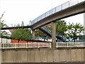
Head for Heights
This two-stage footbridge across the M32 at Baptist Mills, Bristol, is quite narrow and open to the elements. Not a crossing for those suffering from vertigo. The red brick building behind it is St. Werburgh's Community Hall.
Image: © Roger May
Taken: 19 Oct 2005
0.08 miles
6
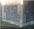
Ordnance Survey Cut Mark
This OS cut mark can be found on the NE angle of the Greek Orthodox Church. It marks a point 15.850m above mean sea level.
Image: © Adrian Dust
Taken: 19 Jul 2021
0.09 miles
7
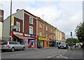
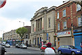
Shops on Stapledon Road, Bristol
A row of shops on the A432, seen from the junction with Belmont Road.
Image: © Derek Harper
Taken: 12 Oct 2017
0.09 miles
8
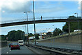
On the M32
Footbridge over the M32 at Easton.
Image: © Robert Ashby
Taken: 16 Aug 2014
0.10 miles
9
M32 Motorway - footbridge near junction 3
Image: © J Whatley
Taken: 22 Sep 2010
0.10 miles
10
2011 : Kensington Baptist Church and shops, Stapleton Road
On the A432.
A lone plane tree keeps up the struggle.
Image: © Maurice Pullin
Taken: 17 Apr 2011
0.10 miles