IMAGES TAKEN NEAR TO
Nicholas Road, BRISTOL, BS5 0LX
Introduction
This page details the photographs taken nearby to Nicholas Road, BS5 0LX by members of the Geograph project.
The Geograph project started in 2005 with the aim of publishing, organising and preserving representative images for every square kilometre of Great Britain, Ireland and the Isle of Man.

There are currently over 7.5m images from over14,400 individuals and you can help contribute to the project by visiting https://www.geograph.org.uk
Image Map
Images are licensed for reuse under creativecommons.org/licenses/by-sa/2.0
Notes
- Clicking on the map will re-center to the selected point.
- The higher the marker number, the further away the image location is from the centre of the postcode.
Image Listing (103 Images Found)
Images are licensed for reuse under creativecommons.org/licenses/by-sa/2.0
Image
Details
Distance
2
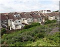
Rear of houses, Easton
The houses front onto Lawrence Avenue. In the background are tower blocks; from left to right, Croyodon House, Lansdowne Court, Twinnell House and Rawnsley House.
Image: © Derek Harper
Taken: 1 Apr 2019
0.04 miles
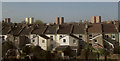
3
Heron Road
A residential street where unsurprisingly parking is always difficult.
Image: © Bill Boaden
Taken: 14 Apr 2017
0.06 miles
4
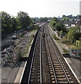
Railway SSE of Stapleton Road station, Bristol
Viewed from this https://www.geograph.org.uk/photo/6207074 footbridge in early September 2018 when work is in progress to add two extra tracks to the route. Next stations ahead are Lawrence Hill and Bristol Temple Meads.
Image: © Jaggery
Taken: 5 Sep 2018
0.06 miles
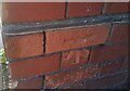
5
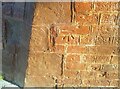
Ordnance Survey Cut Mark
This OS cut mark can be found on the NW buttress of the railway bridge on Bannerman Road. It marks a point 12.119m above mean sea level.
Image: © Adrian Dust
Taken: 19 Jul 2021
0.07 miles
6
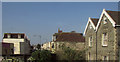
Houses on St Mark' Road, Bristol
A view from the main railway line at St Werbergh's.
Image: © Derek Harper
Taken: 1 Apr 2019
0.07 miles
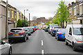
7
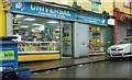
Shop on St Mark's Road, Bristol
The Universal Convenience Store is just west of the railway bridge. It's raining very hard.
Image: © Derek Harper
Taken: 19 Oct 2017
0.07 miles
8
Stapleton Road railway station, Bristol, 2013
Opened in 1863 by the Bristol and South Wales Union Railway on what is now the line from Bristol Temple Meads towards the Severn Tunnel, Bristol Parkway etc. View south towards Lawrence Hill and Bristol. The station used to have four platforms but the two furthest to the left, behind the fence, were redundant at the time this image was taken.
Compare with Image taken some 8 years later from a similar viewpoint.
Image: © Nigel Thompson
Taken: 30 Apr 2013
0.09 miles
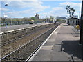
9
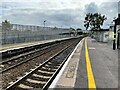
Stapleton Road railway station, Bristol
Opened in 1863 by the Bristol & South Wales Union Railway on what is now the line from Bristol Temple Meads towards the Severn Tunnel, Bristol Parkway etc.
View south towards Lawrence Hill and Bristol. The station used to have four platforms but the two furthest to the left, behind the mammoth footbridge structure, were redundant at the time this image was taken, despite the track having been recently re-quadrupled (hidden from view behind the mammoth footbridge structure!). Compare with Image
Image: © Nigel Thompson
Taken: 25 Sep 2021
0.10 miles
10
Ordnance Survey Cut Mark
This OS cut mark can be found on the NW angle of the Gym (Former Works) on Roman Road. It marks a point 13.689m above mean sea level.
Image: © Adrian Dust
Taken: 19 Jul 2021
0.10 miles