IMAGES TAKEN NEAR TO
Croydon Street, BRISTOL, BS5 0DT
Introduction
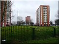
This page details the photographs taken nearby to Croydon Street, BS5 0DT by members of the Geograph project.
The Geograph project started in 2005 with the aim of publishing, organising and preserving representative images for every square kilometre of Great Britain, Ireland and the Isle of Man.

There are currently over 7.5m images from over14,400 individuals and you can help contribute to the project by visiting https://www.geograph.org.uk
Image Map
Images are licensed for reuse under creativecommons.org/licenses/by-sa/2.0
Notes
- Clicking on the map will re-center to the selected point.
- The higher the marker number, the further away the image location is from the centre of the postcode.
Image Listing (70 Images Found)
Images are licensed for reuse under creativecommons.org/licenses/by-sa/2.0
Image
Details
Distance
1
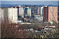
Bristol : City Scenery
Looking across the city scenery with apartment blocks in view.
Image: © Lewis Clarke
Taken: 24 Mar 2015
0.03 miles
2
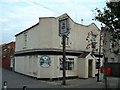
The Chelsea Pub, Easton Bristol
Good ale in a very mixed urban area
Image: © John Phillips
Taken: 6 Sep 2003
0.03 miles
3
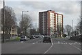
Bristol : Lawrence Hill
Lawrence Hill with a block of flats known as Baynton House in view.
Image: © Lewis Clarke
Taken: 1 Feb 2013
0.05 miles
4
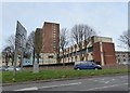
Block of flats at the bottom of Lawrence Hill
Image: © Eirian Evans
Taken: 1 Feb 2016
0.05 miles
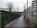
7
Flats off Barrow Road
Seen from the Bristol and Bath Railway Path.
Image: © Christine Johnstone
Taken: 23 Mar 2013
0.11 miles
8
Cyclist on the Bristol & Bath Railway Path
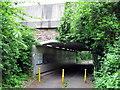
Heading south towards the A420 road bridge.
Image: © Christine Johnstone
Taken: 23 Mar 2013
0.12 miles
10
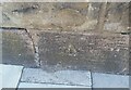
Ordnance Survey Cut Mark
This OS cut mark can be found on the north parapet of the railway bridge on Laurence Hill. It marks a point 22.772m above mean sea level.
Image: © Adrian Dust
Taken: 19 Jul 2021
0.12 miles