IMAGES TAKEN NEAR TO
Hapgood Street, BRISTOL, BS5 0DD
Introduction
This page details the photographs taken nearby to Hapgood Street, BS5 0DD by members of the Geograph project.
The Geograph project started in 2005 with the aim of publishing, organising and preserving representative images for every square kilometre of Great Britain, Ireland and the Isle of Man.

There are currently over 7.5m images from over14,400 individuals and you can help contribute to the project by visiting https://www.geograph.org.uk
Image Map
Images are licensed for reuse under creativecommons.org/licenses/by-sa/2.0
Notes
- Clicking on the map will re-center to the selected point.
- The higher the marker number, the further away the image location is from the centre of the postcode.
Image Listing (67 Images Found)
Images are licensed for reuse under creativecommons.org/licenses/by-sa/2.0
Image
Details
Distance
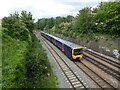
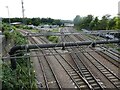
2
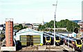
Dr Day's Jn
Passenger train at Barton Hill, near Bristol Temple Meads.
Image: © Wayland Smith
Taken: 23 Apr 2010
0.07 miles
4
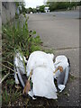
Downed on Barrow Road
A gull (possibly a black-backed gull) lies lifeless on the busy Barrow Road bridge, presumably as a result of a vehicle strike.
Image: © Neil Owen
Taken: 5 May 2022
0.08 miles
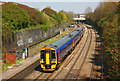
6
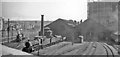
Bristol Barrow Road Locomotive Depot in its last days, 1965
Viewed from the Barrow Road bridge, the depot is seen here in its dying days - it was closed on 20/11/65 - and just three ex-GWR 4-6-0s ('Grange' Nos. 6857/72 and 'Hall' No. 6910) are in view, displaced from Bristol St Philips Marsh. The Depot had been a major one of the Midland (later LMSR), serving their main line into Bristol from Birmingham, Derby and the North.
Image: © Ben Brooksbank
Taken: 31 Jul 1965
0.08 miles
7
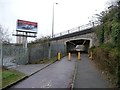
Heritage Passage
According to its mural, this subway was created in 1994. It takes the cycle path under the A4320.
Image: © Christine Johnstone
Taken: 23 Mar 2013
0.09 miles
8
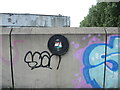
Barrow Road Bridge plaque
Dated 1994 (when the dual carriageway was built over the old shunting yards and sidings that lay below), the plaque has avoided most of the paint.
Image: © Neil Owen
Taken: 5 May 2022
0.09 miles
10
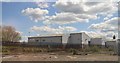
Arriva Train Care Depot, St Philips, Bristol 2
A view from the A4320 (a.k.a. St Philip's Causeway) with the city and the tower and steeple of St Mary's Redcliffe in the distance.
Image: © David Hallam-Jones
Taken: 13 Aug 2017
0.14 miles