IMAGES TAKEN NEAR TO
BS49 5EH
Introduction
This page details the photographs taken nearby to BS49 5EH by members of the Geograph project.
The Geograph project started in 2005 with the aim of publishing, organising and preserving representative images for every square kilometre of Great Britain, Ireland and the Isle of Man.

There are currently over 7.5m images from over14,400 individuals and you can help contribute to the project by visiting https://www.geograph.org.uk
Image Map
Images are licensed for reuse under creativecommons.org/licenses/by-sa/2.0
Notes
- Clicking on the map will re-center to the selected point.
- The higher the marker number, the further away the image location is from the centre of the postcode.
Image Listing (23 Images Found)
Images are licensed for reuse under creativecommons.org/licenses/by-sa/2.0
Image
Details
Distance
1
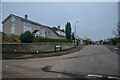
Congresbury : Cobthorn Way
Looking along Cobthorn Way off Wrington Lane.
Image: © Lewis Clarke
Taken: 24 Jan 2022
0.04 miles
2

Congresbury : Wrington Lane
Looking along the lane.
Image: © Lewis Clarke
Taken: 24 Jan 2022
0.05 miles
3
Congresbury : Wrington Lane
Looking along Wrington Lane.
Image: © Lewis Clarke
Taken: 24 Jan 2022
0.07 miles
4
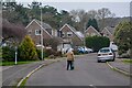
Congresbury : Wrington Mead
Looking along Wrington Mead off Wrington Lane.
Image: © Lewis Clarke
Taken: 24 Jan 2022
0.11 miles
5
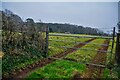
Congresbury : Grassy Field & Gate
A grassy field beyond the gate.
Image: © Lewis Clarke
Taken: 24 Jan 2022
0.12 miles
6
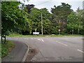
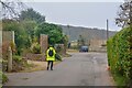
Junction of Wrington Road / A370 Bristol Road
T junction where Wrington Road ends at the A370 Bristol Road in Congresbury. Dropped kerb opposite between the road name signs is for access to the cycle lane that runs up Wood Hill.
Image: © Kevin Pearson
Taken: 25 Jul 2021
0.13 miles
7
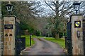
Congresbury : Woodland Park
Looking along a driveway to Woodland Park.
Image: © Lewis Clarke
Taken: 24 Jan 2022
0.13 miles
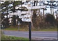
9
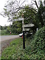
Direction Sign - Signpost on the A370 Bristol Road
Located on the south side of the crossroads of the A370 Bristol Road / Rhodyate Hill, Wood Hill and Wrington Road in Congresbury parish. 4 arms, 1 missing, and pyramid finial. For an older photo before an A370; CONGRESBURY / WESTON-S-MARE arm was lost, see https://www.geograph.org.uk/photo/6051263.
Milestone Society National ID: SO_ST4464
Image: © Roadside Relics
Taken: 16 Oct 2023
0.15 miles
10
Direction Sign - Signpost on the A370 Bristol Road
Pyramid finial - 4 arms; Somerset SCC pyramid by the UC road, in parish of Congresbury (North Somerset District), on the south side of the crossroads of the A370 Bristol Road / Rhodyate Hill, Wood Hill and Wrington Road. For a more recent photo after the A370; CONGRESBURY / WESTON-S-MARE arm was lost, see https://www.geograph.org.uk/photo/7650999.
Surveyed
Milestone Society National ID: SO_ST4464
Image: © Milestone Society
Taken: 9 Feb 2015
0.15 miles