IMAGES TAKEN NEAR TO
Woodview Drive, BRISTOL, BS49 4NN
Introduction
This page details the photographs taken nearby to Woodview Drive, BS49 4NN by members of the Geograph project.
The Geograph project started in 2005 with the aim of publishing, organising and preserving representative images for every square kilometre of Great Britain, Ireland and the Isle of Man.

There are currently over 7.5m images from over14,400 individuals and you can help contribute to the project by visiting https://www.geograph.org.uk
Image Map
Images are licensed for reuse under creativecommons.org/licenses/by-sa/2.0
Notes
- Clicking on the map will re-center to the selected point.
- The higher the marker number, the further away the image location is from the centre of the postcode.
Image Listing (56 Images Found)
Images are licensed for reuse under creativecommons.org/licenses/by-sa/2.0
Image
Details
Distance
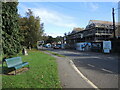
1
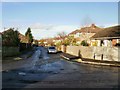
Cleeve Drive , Cleeve
Viewed from the junction with Millier Road, which runs parallel with the A370 for about 100 metres in the centre of Cleeve.
Image: © Jaggery
Taken: 28 Nov 2009
0.03 miles
2
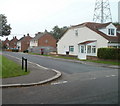
Eastern corner of Woodview Drive and Millier Road, Cleeve
The pylon is about 20 metres behind the house.
Image: © Jaggery
Taken: 9 Oct 2010
0.03 miles
3
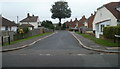
Woodview Drive, Cleeve
Viewed from Millier Road on a misty day in autumn.
Image: © Jaggery
Taken: 9 Oct 2010
0.03 miles
4
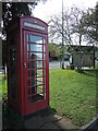
Millier Road phone box
Against all odds, it actually has a functioning telephone in it.
Image: © Neil Owen
Taken: 4 Nov 2021
0.06 miles
5
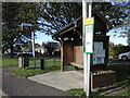
Bus shelter in Cleeve
Modern digital information and a wooden shelter with paper parish notices.
Image: © Neil Owen
Taken: 4 Nov 2021
0.06 miles
6
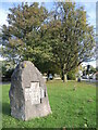
Cleeve Jubilee stone
A large lump of rock stands in Cleeve as a commemorative feature of the Golden Jubilee of 2002.
Image: © Neil Owen
Taken: 4 Nov 2021
0.07 miles
7
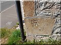
Ordnance Survey Cut Mark
This OS cut mark can be found on the roadside building NW side of the road. It marks a point 28.383m above mean sea level.
Image: © Adrian Dust
Taken: 29 Jul 2022
0.07 miles
8
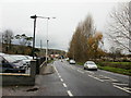
Main Road, Cleeve
Looking west along Main Road (the A370) on a dull November morning with rain threatening. On the left, in the middle distance, is the Lord Nelson pub. http://www.geograph.org.uk/photo/1598573
Image: © Jaggery
Taken: 28 Nov 2009
0.08 miles
9
In place of his lordship
The Lord Nelson pub is no more and a new retail and office development is going up on the site.
Image: © Neil Owen
Taken: 4 Nov 2021
0.08 miles
10
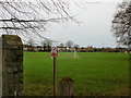
Playing Field, Cleeve
Looking across the King George V Playing Field from the Main Road (A370) entrance. The Sinclair Pavilion on the field is home to Cleeve Cricket Club, Cleeve West Town Football Club, Cleeve Lawn Tennis Club as well as many local skittles teams.
Image: © Jaggery
Taken: 28 Nov 2009
0.08 miles