IMAGES TAKEN NEAR TO
Claverham Park, BRISTOL, BS49 4LS
Introduction
This page details the photographs taken nearby to Claverham Park, BS49 4LS by members of the Geograph project.
The Geograph project started in 2005 with the aim of publishing, organising and preserving representative images for every square kilometre of Great Britain, Ireland and the Isle of Man.

There are currently over 7.5m images from over14,400 individuals and you can help contribute to the project by visiting https://www.geograph.org.uk
Image Map
Images are licensed for reuse under creativecommons.org/licenses/by-sa/2.0
Notes
- Clicking on the map will re-center to the selected point.
- The higher the marker number, the further away the image location is from the centre of the postcode.
Image Listing (18 Images Found)
Images are licensed for reuse under creativecommons.org/licenses/by-sa/2.0
Image
Details
Distance
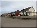
1
Claverham Road looking west
Claverham Road looking west towards Bishops Road. Shows the repositioned post box after the closure of the post office.
Image: © Pauline Leverett
Taken: 2 Nov 2008
0.03 miles
2
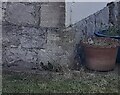
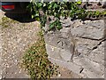
Ordnance Survey Cut Mark
This OS cut mark can be found on the Old Chapel. It marks a point 14.192m above mean sea level.
Image: © Adrian Dust
Taken: 29 Jul 2022
0.06 miles
4
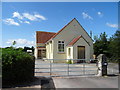
Steamcross Community Church, Claverham
Dated 1927.
Image: © JThomas
Taken: 12 Jul 2019
0.08 miles
5
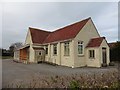
Steamcross Community Church, Claverham
Image: © Roger Cornfoot
Taken: 13 Mar 2020
0.08 miles
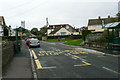
6
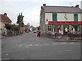
Claverham High Street & Post Office
At the heart of this delightful village lies the Post Office and village stores. Looking up High Street from the Claverham Road. For more information on Claverham see the village website http://www.claverhamvillage.co.uk/
Image: © FollowMeChaps
Taken: 4 Jan 2006
0.08 miles
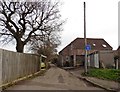
7
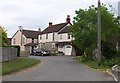
Streamcross, Claverham
The lane, which links farms along the edge of the levels, bends past these houses into the centre of the village.
Image: © Derek Harper
Taken: 16 May 2011
0.08 miles
8
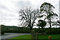
Chestnut Tree - Claverham
Dead Chestnut tree which gave its name to Chestnut Drive, Claverham
Image: © Pauline Leverett
Taken: 23 Oct 2009
0.14 miles
9
Ordnance Survey Cut Mark
This OS cut mark can be found on the wall of No157 Claverham Road. It marks a point 13.521m above mean sea level.
Image: © Adrian Dust
Taken: 29 Jul 2022
0.14 miles