IMAGES TAKEN NEAR TO
Tripps Corner, BRISTOL, BS49 4JW
Introduction
This page details the photographs taken nearby to Tripps Corner, BS49 4JW by members of the Geograph project.
The Geograph project started in 2005 with the aim of publishing, organising and preserving representative images for every square kilometre of Great Britain, Ireland and the Isle of Man.

There are currently over 7.5m images from over14,400 individuals and you can help contribute to the project by visiting https://www.geograph.org.uk
Image Map
Images are licensed for reuse under creativecommons.org/licenses/by-sa/2.0
Notes
- Clicking on the map will re-center to the selected point.
- The higher the marker number, the further away the image location is from the centre of the postcode.
Image Listing (54 Images Found)
Images are licensed for reuse under creativecommons.org/licenses/by-sa/2.0
Image
Details
Distance
1
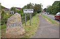
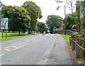
Yatton: Fair Trade village
"Yatton secured Fairtrade status in 2004 from the Fairtrade Foundation" http://www.thisisbristol.co.uk/news/Signs-celebrate-Yatton-village-s-Fairtrade-links/article-741190-detail/article.html http://www.fairtrade.org.uk/get_involved/campaigns/fairtrade_towns/default.aspx. The signs are on the B3133 at the southern entrance to the village.
Image: © Derek Harper
Taken: 16 May 2011
0.01 miles
2
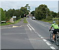
Cycling into Yatton
A cyclist descends Frost Hill (B3133) past the Mendip Road junction.
Someone, perhaps with some kind of grievance against the village, has placed grey tape across most of the wording Fair Trade Village, under Yatton on the boundary sign.
Image: © Jaggery
Taken: 23 Jul 2011
0.02 miles
3
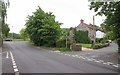
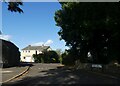
Mendip Road and Frost Hill, Yatton
Frost Hill, the no through road on the right, must once have been the main road through the village. It's now bypassed by the road the car on the left is travelling along.
Image: © Derek Harper
Taken: 16 May 2011
0.02 miles
4
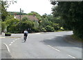
Cycling around the bend, Yatton
Two cyclists on the B3133 pass the Henley Lane junction. Viewed from High Street, which beyond Henley Lane is renamed Frost Hill.
Image: © Jaggery
Taken: 23 Jul 2011
0.05 miles
5
Frost Hill near Yatton
The B3133, here named Frost Hill, heads south away from Yatton towards Congresbury.
Image: © Jaggery
Taken: 23 Jul 2011
0.08 miles
6
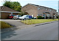
Mitford Slade Court, Yatton
Located in Mendip Road, Mitford Slade Court is a sheltered housing complex of 23 self-contained flats, built in 1974.
Image: © Jaggery
Taken: 23 Jul 2011
0.08 miles
7
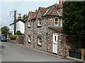
Lestrem House, Yatton
Located on a part of the former route of Frost Hill, which now follows a straighter course a few metres to the east. The neighbouring house is The Old Sweet Shop.
Image: © Jaggery
Taken: 23 Jul 2011
0.08 miles
8
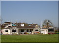
Claverham Cricket Club
Based here on the outskirts of Yatton, the club's Wood Memorial Ground is home to several sides, male and female, young and old. The club began playing in 1905 and have been here since before the Second World War.
Lots of preparatory work has been ongoing as the club is hosting the first game of the season this weekend; the warm weather is both inviting and appropriate.
Image: © Neil Owen
Taken: 19 Apr 2018
0.09 miles
9
Henley Lodge, Yatton
A private cul-de-sac. How many roads in housing developments are called "lodge"?
Image: © David Smith
Taken: 1 Oct 2021
0.10 miles
10
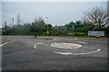
Yatton : High Street
A roundabout connecting High Street with Claverham Road.
Image: © Lewis Clarke
Taken: 24 Jan 2022
0.12 miles