1
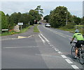
Mendip Road and Frost Hill, Yatton
Frost Hill, the no through road on the right, must once have been the main road through the village. It's now bypassed by the road the car on the left is travelling along.
Image: © Derek Harper
Taken: 16 May 2011
0.05 miles
2
Cycling into Yatton
A cyclist descends Frost Hill (B3133) past the Mendip Road junction.
Someone, perhaps with some kind of grievance against the village, has placed grey tape across most of the wording Fair Trade Village, under Yatton on the boundary sign.
Image: © Jaggery
Taken: 23 Jul 2011
0.07 miles
3
Yatton: Fair Trade village
"Yatton secured Fairtrade status in 2004 from the Fairtrade Foundation" http://www.thisisbristol.co.uk/news/Signs-celebrate-Yatton-village-s-Fairtrade-links/article-741190-detail/article.html http://www.fairtrade.org.uk/get_involved/campaigns/fairtrade_towns/default.aspx. The signs are on the B3133 at the southern entrance to the village.
Image: © Derek Harper
Taken: 16 May 2011
0.08 miles
4
Mitford Slade Court, Yatton
Located in Mendip Road, Mitford Slade Court is a sheltered housing complex of 23 self-contained flats, built in 1974.
Image: © Jaggery
Taken: 23 Jul 2011
0.08 miles
5
Lestrem House, Yatton
Located on a part of the former route of Frost Hill, which now follows a straighter course a few metres to the east. The neighbouring house is The Old Sweet Shop.
Image: © Jaggery
Taken: 23 Jul 2011
0.08 miles
6
Frost Hill near Yatton
The B3133, here named Frost Hill, heads south away from Yatton towards Congresbury.
Image: © Jaggery
Taken: 23 Jul 2011
0.08 miles
7
Restriction in Rock Road
The road skirts the football pitch and links with the main High Street. However, four-wheeled traffic cannot use it as there is a large wall to deal with. There are few road signs about the wall and fencing, oddly. They have an air of sudden appearance about them, looking somewhat like someone's garden in the middle of the road.
Image: © Neil Owen
Taken: 29 Oct 2021
0.10 miles
8
Youth club football pitch
Some provision for young people in Yatton: a pitch, outdoor courts and a pavilion.
Image: © Neil Owen
Taken: 29 Oct 2021
0.10 miles
9
Cycling around the bend, Yatton
Two cyclists on the B3133 pass the Henley Lane junction. Viewed from High Street, which beyond Henley Lane is renamed Frost Hill.
Image: © Jaggery
Taken: 23 Jul 2011
0.11 miles
10
Yatton fire station
Built in 1973.
Image: © Neil Owen
Taken: 29 Oct 2021
0.11 miles


