IMAGES TAKEN NEAR TO
Stowey Road, BRISTOL, BS49 4HU
Introduction
This page details the photographs taken nearby to Stowey Road, BS49 4HU by members of the Geograph project.
The Geograph project started in 2005 with the aim of publishing, organising and preserving representative images for every square kilometre of Great Britain, Ireland and the Isle of Man.

There are currently over 7.5m images from over14,400 individuals and you can help contribute to the project by visiting https://www.geograph.org.uk
Image Map
Images are licensed for reuse under creativecommons.org/licenses/by-sa/2.0
Notes
- Clicking on the map will re-center to the selected point.
- The higher the marker number, the further away the image location is from the centre of the postcode.
Image Listing (124 Images Found)
Images are licensed for reuse under creativecommons.org/licenses/by-sa/2.0
Image
Details
Distance
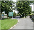
1
A green jubilee
A tree outside Yatton junior school was planted in 2012, as part of the Queen's Diamond Jubilee activities. Sixty saplings were planted in the area.
Image: © Neil Owen
Taken: 29 Oct 2021
0.04 miles
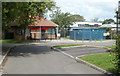
2
Yatton schools
Formally the Yatton Church of England Junior and Yatton Infant Schools.
Image: © Neil Owen
Taken: 29 Oct 2021
0.04 miles
3
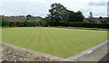
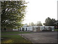
Bowling green, Yatton Bowling Club
Located on the north side of High Street, bordering Well Lane.
Image: © Jaggery
Taken: 23 Jul 2011
0.09 miles
4
Entrance to Yatton Church of England Junior School and Infant School
The entrance gates to the voluntary controlled schools are along a lane about 80 metres from High Street.
Image: © Jaggery
Taken: 23 Jul 2011
0.09 miles
5
SE side of the Yatton Church of England schools site
Viewed through the entrance gates. http://www.geograph.org.uk/photo/2958574 The schools on the site are Yatton Church of England Junior School and Yatton Church of England Infants School.
Image: © Jaggery
Taken: 23 Jul 2011
0.09 miles
6
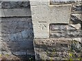
Ordnance Survey Cut Mark
This OS cut mark can be found on the library. It marks a point 10.814m above mean sea level.
Image: © Adrian Dust
Taken: 29 Jul 2022
0.12 miles
7
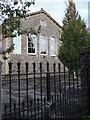
Yatton library
Based in the former school, which prior to that was a Friends' Meeting House.
Image: © Neil Owen
Taken: 29 Oct 2021
0.12 miles
9
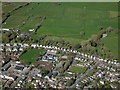
Yatton from the air
Looking north over the town towards Stowey Road and the recreation ground.
Image: © Thomas Nugent
Taken: 7 Apr 2023
0.13 miles