IMAGES TAKEN NEAR TO
Stowey Road, BRISTOL, BS49 4HS
Introduction
This page details the photographs taken nearby to Stowey Road, BS49 4HS by members of the Geograph project.
The Geograph project started in 2005 with the aim of publishing, organising and preserving representative images for every square kilometre of Great Britain, Ireland and the Isle of Man.

There are currently over 7.5m images from over14,400 individuals and you can help contribute to the project by visiting https://www.geograph.org.uk
Image Map (Loading...)


Getting Data...Please wait
Leaflet Map data © OpenStreetMap
Images are licensed for reuse under creativecommons.org/licenses/by-sa/2.0
Notes
- Clicking on the map will re-center to the selected point.
- The higher the marker number, the further away the image location is from the centre of the postcode.
Image Listing (74 Images Found)
Images are licensed for reuse under creativecommons.org/licenses/by-sa/2.0
Image
Details
Distance
1
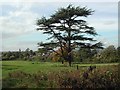
Yatton Church looking NW over grid square ST4365
View from SE corner of grid square ST4365 looking NW. Parish church, also in this grid can be seen in middle distance. Village also visible between trees.
Image: © FollowMeChaps
Taken: 22 Oct 2005
0.03 miles
2
Yatton : Westaway Park
Westaway Park off Claverham Road.
Image: © Lewis Clarke
Taken: 24 Jan 2022
0.11 miles
3
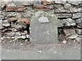
Boundary Stone
Marked as 'Stone' on old maps. North side of Claverham Road.
Image: © Adrian Dust
Taken: 29 Jul 2022
0.12 miles
5
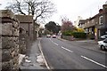
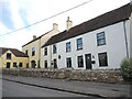
Yatton High Street looking towards top Scaur
On the right is AP cleaners (previously the 'Bell Inn'). The tall white house is rock house on the corner of Rock Road. On the left is Edwards the butchers.
Image: © Gareth and Lisa Wonfor
Taken: 13 Apr 2006
0.12 miles
6
Old Boundary Marker on Claverham Road, Yatton
Boundary Marker against a stone wall on the northwest side of the junction of Claverham Road and Stowey Park. Yatton parish. No inscription and not on a boundary. See also https://www.geograph.org.uk/photo/7241064.
Milestone Society National ID: SO_YATTON01bm
Image: © Roadside Relics
Taken: 16 Oct 2023
0.12 miles
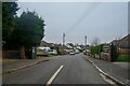
7
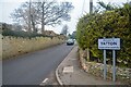
Yatton : Claverham Road
Looking along Claverham Road with a welcome to Yatton sign.
Image: © Lewis Clarke
Taken: 24 Jan 2022
0.13 miles
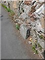
8
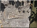
Ordnance Survey Cut Mark
This inverted OS cut mark can be found on the wall SW side of the road. It marked a point 18.937m above mean sea level.
Image: © Adrian Dust
Taken: 29 Jul 2022
0.13 miles
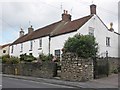
9
Closed pub, but with a lone relic
These buildings were the Prince of Orange up to a few years ago before it closed for good. But on the wall is a reminder of when it used to be a busy pub with lots of energetic visitors - see Image] for a look at the C.T.C. plaque.
Image: © Neil Owen
Taken: 29 Oct 2021
0.14 miles
10
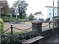
A seat by the war memorial
Facing onto the main road is Yatton's space to remember the fallen.
Image: © Neil Owen
Taken: 29 Oct 2021
0.14 miles