IMAGES TAKEN NEAR TO
Derham Close, BRISTOL, BS49 4BU
Introduction
This page details the photographs taken nearby to Derham Close, BS49 4BU by members of the Geograph project.
The Geograph project started in 2005 with the aim of publishing, organising and preserving representative images for every square kilometre of Great Britain, Ireland and the Isle of Man.

There are currently over 7.5m images from over14,400 individuals and you can help contribute to the project by visiting https://www.geograph.org.uk
Image Map
Images are licensed for reuse under creativecommons.org/licenses/by-sa/2.0
Notes
- Clicking on the map will re-center to the selected point.
- The higher the marker number, the further away the image location is from the centre of the postcode.
Image Listing (124 Images Found)
Images are licensed for reuse under creativecommons.org/licenses/by-sa/2.0
Image
Details
Distance
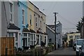
1
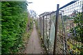
Yatton : Footpath
A footpath between Elborough Avenue and Derham Park.
Image: © Lewis Clarke
Taken: 24 Jan 2022
0.02 miles
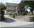
2
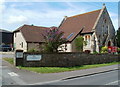
Yatton Methodist Church
Located in High Street.
Image: © Jaggery
Taken: 23 Jul 2011
0.03 miles
3
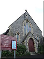
Yatton Methodist Church
The church on the High Street is a more modern building. Originally a United Free Methodist building stood immediately to the left of shot, but which is now lost.
Image: © Neil Owen
Taken: 29 Oct 2021
0.04 miles
4
Yatton : Derham Park
Looking along Derham Park.
Image: © Lewis Clarke
Taken: 24 Jan 2022
0.05 miles
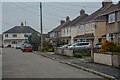
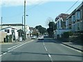
5
Yatton : Elborough Avenue
Looking along Elborough Avenue.
Image: © Lewis Clarke
Taken: 24 Jan 2022
0.05 miles
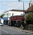
7
Pullins bakery shop, Yatton
The shop is located at 110 High Street. The wide sign above the awnings shows
Award Winning Family Craft Bakery & Purveyors of Fine Food.
Established by Thomas Pullin in September 1925, Pullins now has three bakery shops. The other two are in Clevedon. Pullins bakery premises are to the SE of this shop, at 29 High Street. http://www.geograph.org.uk/photo/2958713
On the right is a Mace store.
Image: © Jaggery
Taken: 23 Jul 2011
0.06 miles
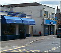
8
Cork and Fork, Yatton
Off licence and food store located in a High Street building that was formerly a Thresher Wine Shop.
Image: © Jaggery
Taken: 23 Jul 2011
0.06 miles
9
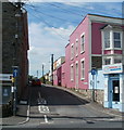
Elborough Avenue, Yatton
Viewed across High Street, past the corner premises of Ironing 4 U.
Image: © Jaggery
Taken: 23 Jul 2011
0.06 miles
10
Yatton Masonic Hall
Located at 89 High Street, Yatton. From c1890 to the 1920s, the building, then known as Larchmount House,was a private school for boarders and day girls.
Image: © Jaggery
Taken: 23 Jul 2011
0.06 miles