IMAGES TAKEN NEAR TO
Dorchester Close, BRISTOL, BS48 4QW
Introduction
This page details the photographs taken nearby to Dorchester Close, BS48 4QW by members of the Geograph project.
The Geograph project started in 2005 with the aim of publishing, organising and preserving representative images for every square kilometre of Great Britain, Ireland and the Isle of Man.

There are currently over 7.5m images from over14,400 individuals and you can help contribute to the project by visiting https://www.geograph.org.uk
Image Map (Loading...)


Getting Data...Please wait
Leaflet Map data © OpenStreetMap
Images are licensed for reuse under creativecommons.org/licenses/by-sa/2.0
Notes
- Clicking on the map will re-center to the selected point.
- The higher the marker number, the further away the image location is from the centre of the postcode.
Image Listing (34 Images Found)
Images are licensed for reuse under creativecommons.org/licenses/by-sa/2.0
Image
Details
Distance
1
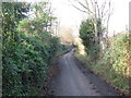
Haslands (Lane)
Formerly the main East West road through Nailsea before modern developments.
Image: © Dr Duncan Pepper
Taken: 13 Jan 2012
0.04 miles
2
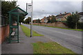
Bus stop on Queens Road
Bus stop on Queens Road in Nailsea.
Image: © Philip Halling
Taken: 10 Sep 2011
0.12 miles
3
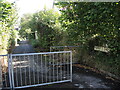
West entrance to Beckett's Lane
Off The Perrings, the footpath was once the road to the Pink Cottage of old.
Image: © Neil Owen
Taken: 29 Sep 2021
0.15 miles
4
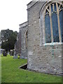
Channeling all around the church
Holy Trinity church was founded in the fifteenth century in a rural part of Somerset, far from what would later grow to be Nailsea. The church is set into the ground with the level below the surrounding earth. Note the small gap in the base of the buttress, and the copper stains from the window mesh.
Image: © Neil Owen
Taken: 29 Sep 2021
0.15 miles
5
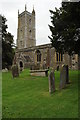
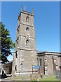
Nailsea church
Nailsea church is dedicated Holy Trinity.
Image: © Philip Halling
Taken: 10 Sep 2011
0.15 miles
6
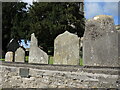
No more room
A small plaque on the wall of Holy Trinity church records that this was the site of the parish room (Vestry Hall) until its disuse in 1963.
Image: © Neil Owen
Taken: 29 Sep 2021
0.15 miles
7
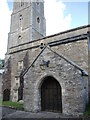
Holy Trinity porch
The south entrance was embellished when a porch was built in 1712 and restored in 1861.
Image: © Neil Owen
Taken: 29 Sep 2021
0.16 miles
8
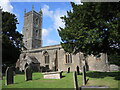
Holy Trinity on the south side of Nailsea
Built in the fifteenth century and Grade I listed.
Image: © Neil Owen
Taken: 29 Sep 2021
0.16 miles
10
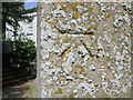
Ordnance Survey Cut Mark
This OS cut mark can be found a buttress of Holy Trinity Church. It marks a point 34.196m above mean sea level.
Image: © Adrian Dust
Taken: 28 Jun 2014
0.16 miles