IMAGES TAKEN NEAR TO
Charterhouse Close, BRISTOL, BS48 4PU
Introduction
This page details the photographs taken nearby to Charterhouse Close, BS48 4PU by members of the Geograph project.
The Geograph project started in 2005 with the aim of publishing, organising and preserving representative images for every square kilometre of Great Britain, Ireland and the Isle of Man.

There are currently over 7.5m images from over14,400 individuals and you can help contribute to the project by visiting https://www.geograph.org.uk
Image Map
Images are licensed for reuse under creativecommons.org/licenses/by-sa/2.0
Notes
- Clicking on the map will re-center to the selected point.
- The higher the marker number, the further away the image location is from the centre of the postcode.
Image Listing (28 Images Found)
Images are licensed for reuse under creativecommons.org/licenses/by-sa/2.0
Image
Details
Distance
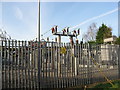
2
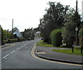
Wires over Station Road, Nailsea
Over Station Road north of the Queens Road junction. http://www.geograph.org.uk/photo/5043830
Image: © Jaggery
Taken: 8 Jun 2016
0.10 miles
3
St Francis' Catholic Primary School, Nailsea
Viewed from Station Road.
Image: © Jaggery
Taken: 13 Jul 2012
0.12 miles
4
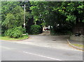
Leafy suburban junction in Nailsea
The junction of Queens Road and leafy Farlers End.
There is no apostrophe on the name signs for both Queens Road and Farlers End.
Image: © Jaggery
Taken: 8 Jun 2016
0.12 miles
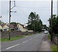
5
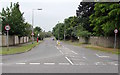
Queens Road from Station Road, Nailsea
The 30mph speed limit on Station Road increases to 40mph on Queens Road.
Image: © Jaggery
Taken: 8 Jun 2016
0.13 miles
6

Warning sign - slippery road, Queens Road, Nailsea
Facing the Station Road junction. In the UK, red-edged triangular signs indicate a warning.
Image: © Jaggery
Taken: 8 Jun 2016
0.13 miles
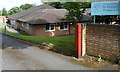
7
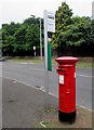
Queen Elizabeth II pillarbox, Queens Road, Nailsea
Alongside a bus stop for First buses towards the town centre.
Image: © Jaggery
Taken: 8 Jun 2016
0.13 miles
8
Station Road directions signs, Nailsea
Facing the eastern end of Queens Road. http://www.geograph.org.uk/photo/5043830
Left (north) on Station Road for Clevedon and Bristol or right for Nailsea & Backwell railway station.
Image: © Jaggery
Taken: 8 Jun 2016
0.14 miles
9
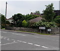
Ash Hayes Road, Nailsea
Viewed across Station Road.
Image: © Jaggery
Taken: 13 Jul 2012
0.14 miles
10
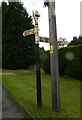
Old Direction Sign - Signpost by Station Road, Nailsea
Pyramid finial - 3 arms; Somerset SCC pyramid (Sheldon) by the UC road, in parish of Nailsea (North Somerset District), Station Road junction with Bucklands Batch and Trendlewood Way, on cut verge by telegraph pole.
To be surveyed
Milestone Society National ID: SO_ST4769
Image: © Alan Rosevear
Taken: 24 Sep 2012
0.15 miles