IMAGES TAKEN NEAR TO
Bucklands Grove, BRISTOL, BS48 4PL
Introduction
This page details the photographs taken nearby to Bucklands Grove, BS48 4PL by members of the Geograph project.
The Geograph project started in 2005 with the aim of publishing, organising and preserving representative images for every square kilometre of Great Britain, Ireland and the Isle of Man.

There are currently over 7.5m images from over14,400 individuals and you can help contribute to the project by visiting https://www.geograph.org.uk
Image Map (Loading...)


Getting Data...Please wait
Leaflet Map data © OpenStreetMap
Images are licensed for reuse under creativecommons.org/licenses/by-sa/2.0
Notes
- Clicking on the map will re-center to the selected point.
- The higher the marker number, the further away the image location is from the centre of the postcode.
Image Listing (49 Images Found)
Images are licensed for reuse under creativecommons.org/licenses/by-sa/2.0
Image
Details
Distance
1
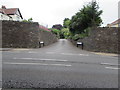
Bucklands Drive, Nailsea
Private dead-end road on the east side of Bucklands Batch in the south of Nailsea.
Image: © Jaggery
Taken: 8 Jun 2016
0.02 miles
2
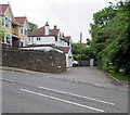
Bucklands Grove, Nailsea
Cul-de-sac on the east side of Bucklands Batch.
Image: © Jaggery
Taken: 8 Jun 2016
0.03 miles
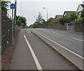
3
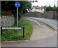
Segregated footpath and cycleway alongside Bucklands Batch, Nailsea
North of the Bucklands Lane junction, a white line on the pavement
separates the footpath on the left from the cycleway on the right.
Image: © Jaggery
Taken: 8 Jun 2016
0.05 miles
4
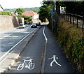
Footpath and cycle lane markers alongside Bucklands Batch, Nailsea
Behind the depiction of a walker, a blue sign shows NO ACCESS FOR CYCLES.
Image: © Jaggery
Taken: 13 Jul 2012
0.07 miles
5
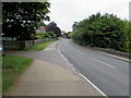
From Station Road to Bucklands Batch, Nailsea
Looking past the Bucklands End junction, where Station Road on this side becomes Bucklands Batch ahead.
Image: © Jaggery
Taken: 8 Jun 2016
0.08 miles
6
End of cycle route sign, Bucklands Batch, Nailsea
The combined footpath and cycle route narrows to a pavement for walkers only.
Image: © Jaggery
Taken: 8 Jun 2016
0.08 miles
7
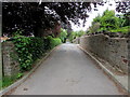
Bucklands Lane, Nailsea
Cul-de-sac on the west side of Bucklands Batch.
Image: © Jaggery
Taken: 8 Jun 2016
0.08 miles
8
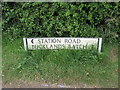
Station Road/Bucklands Batch name sign, Nailsea
Located near the corner of Bucklands End, where Station Road from Backwell is renamed Bucklands Batch.
Image: © Jaggery
Taken: 8 Jun 2016
0.09 miles
9
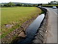
Station Road drainage channel, Nailsea
Located near Backwell Lake.
Image: © Jaggery
Taken: 13 Jul 2012
0.10 miles
10
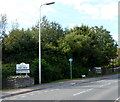
Welcome to Nailsea
Station Road passes from Backwell to Nailsea. Fittingly located in a floral display, a notice below the boundary marker shows South West in bloom Gold award winning town.
Image: © Jaggery
Taken: 13 Jul 2012
0.10 miles