IMAGES TAKEN NEAR TO
West End Lane, BRISTOL, BS48 4DA
Introduction
This page details the photographs taken nearby to West End Lane, BS48 4DA by members of the Geograph project.
The Geograph project started in 2005 with the aim of publishing, organising and preserving representative images for every square kilometre of Great Britain, Ireland and the Isle of Man.

There are currently over 7.5m images from over14,400 individuals and you can help contribute to the project by visiting https://www.geograph.org.uk
Image Map (Loading...)


Getting Data...Please wait
Leaflet Map data © OpenStreetMap
Images are licensed for reuse under creativecommons.org/licenses/by-sa/2.0
Notes
- Clicking on the map will re-center to the selected point.
- The higher the marker number, the further away the image location is from the centre of the postcode.
Image Listing (8 Images Found)
Images are licensed for reuse under creativecommons.org/licenses/by-sa/2.0
Image
Details
Distance
2
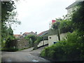
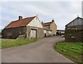
West End Lane
West End Lane at the point where a bridleway turns off to the south, as shown by the signpost.
Image: © Ruth Riddle
Taken: 10 Jul 2012
0.05 miles
4
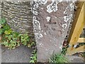
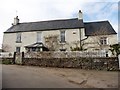
Ordnance Survey Cut Mark
This OS cut mark can be found on the gatepost of The Cottage. It marks a point 9.431m above mean sea level.
Image: © Adrian Dust
Taken: 3 Aug 2022
0.11 miles
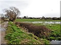
8
Bridge over Parish Brook
Bridge carrying a farm track and bridleway over Parish Brook on Nailsea Moor.
Image: © Philip Halling
Taken: 17 Jul 2014
0.25 miles