IMAGES TAKEN NEAR TO
Hobbs Lane, BRISTOL, BS48 3SU
Introduction
This page details the photographs taken nearby to Hobbs Lane, BS48 3SU by members of the Geograph project.
The Geograph project started in 2005 with the aim of publishing, organising and preserving representative images for every square kilometre of Great Britain, Ireland and the Isle of Man.

There are currently over 7.5m images from over14,400 individuals and you can help contribute to the project by visiting https://www.geograph.org.uk
Image Map (25 Images)


Getting Data...Please wait
Leaflet Map data © OpenStreetMap
Images are licensed for reuse under creativecommons.org/licenses/by-sa/2.0
Notes
- Clicking on the map will re-center to the selected point.
- The higher the marker number, the further away the image location is from the centre of the postcode.
Image Listing (25 Images Found)
Images are licensed for reuse under creativecommons.org/licenses/by-sa/2.0
Image
Details
Distance
1
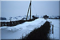
Snow drifts in Hobbs Lane, Barrow Gurney
Image: © Colin Park
Taken: 20 Feb 1978
0.02 miles
2
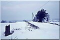
Hobbs Lane, Barrow Gurney
During the severe winter of 1962/63 this was a typical view of many of the minor lanes south of Bristol. This is Hobbs Lane which was a narrow short cut between the A38 and Barrow Gurney. This snow here is around six feet deep. The lane was closed to through traffic a number of years ago but can be still walked.
Image: © Richard Park
Taken: 30 Dec 1962
0.04 miles
3
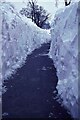
Snow cutting Hobbs Lane, Barrow Gurney
During the severe winter of 1962/63 many properties were entirely cut off from the outside world. Hobbs Lane at Barrow Gurney was one such lane totally blocked by snow. To gain access to a couple of properties this deep snow cutting was made from the nearby A38.
Image: © Richard Park
Taken: 30 Dec 1962
0.04 miles
4
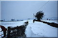
Snow drifts in Hobbs Lane, Barrow Gurney
Image: © Colin Park
Taken: 20 Feb 1978
0.08 miles
6
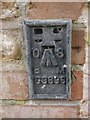
Flush Bracket OSBM G3696: Lake House
Flush bracket benchmark on the north-west angle, north face of a private house at Barrow Gurney. See http://www.bench-marks.org.uk/bm15597 for details.
Image: © Brian Westlake
Taken: 13 Oct 2017
0.09 miles
7
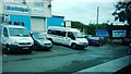
Entrance to Lakeside Spas
Premises of a hot tub firm. Located on Bridgwater Road (A38) opposite Barrow Gurney Reservoir 1.
Image: © Clint Mann
Taken: 3 Sep 2015
0.11 miles
9
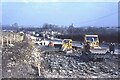
A38 road widening at the Fox & Goose PH, Barrow Gurney
The A38 was the main artery between the Midlands and the West Country prior to the building of the M5 motorway. During 1965 the road was widened to three lanes but this resulted in many serious accidents until the road markings were reconfigured with an overtaking lane southbound and a single lane northbound.
Image: © Richard Park
Taken: Unknown
0.14 miles
10
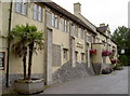
The Fox and Goose, Bridgwater Road
This pub has a place right beside the main A38 between Bristol and the airport, and must have a large amount of passing traffic. A benchmark can be found at the corner nearest the camera - Image
Image: © Neil Owen
Taken: 28 Jul 2011
0.17 miles