IMAGES TAKEN NEAR TO
Barrow Street, BRISTOL, BS48 3RU
Introduction
This page details the photographs taken nearby to Barrow Street, BS48 3RU by members of the Geograph project.
The Geograph project started in 2005 with the aim of publishing, organising and preserving representative images for every square kilometre of Great Britain, Ireland and the Isle of Man.

There are currently over 7.5m images from over14,400 individuals and you can help contribute to the project by visiting https://www.geograph.org.uk
Image Map (Loading...)


Getting Data...Please wait
Leaflet Map data © OpenStreetMap
Images are licensed for reuse under creativecommons.org/licenses/by-sa/2.0
Notes
- Clicking on the map will re-center to the selected point.
- The higher the marker number, the further away the image location is from the centre of the postcode.
Image Listing (6 Images Found)
Images are licensed for reuse under creativecommons.org/licenses/by-sa/2.0
Image
Details
Distance
2
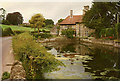
Barrow Gurney: millpond at Lower Barrow Mill
On the Land Yeo, by the B3130 from Chew Magna and Winford to Wraxall and Nailsea. The watermill was rebuilt in 1909 when owned by the Gibbs family of Tyntesfield – the house now owned by the National Trust. It retains an internal 14’ diameter overshot waterwheel used until the 1950s but the mill is not open to the public. This was at one time the lowest of three watermills at Barrow Gurney
Image: © Martin Bodman
Taken: Unknown
0.13 miles
4
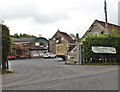
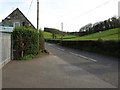
Agricultural merchants at Barrow Mill
Image: © Roger Cornfoot
Taken: 24 Apr 2017
0.16 miles
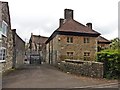
5
The B3130 at Barrow Mill Country Store, Barrow Gurney
Image: © David Gearing
Taken: 9 Apr 2011
0.19 miles
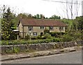
6
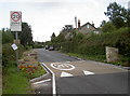
A flowery warning
Barrow Gurney has a notoriously narrow and twisty road that runs right through it. After many years of accidents and highway engineering, this is now the sight that greets motorists: more narrowing.
Image: © Neil Owen
Taken: 17 Aug 2017
0.24 miles