IMAGES TAKEN NEAR TO
Cadogan Grove, BRISTOL, BS48 3QN
Introduction
This page details the photographs taken nearby to Cadogan Grove, BS48 3QN by members of the Geograph project.
The Geograph project started in 2005 with the aim of publishing, organising and preserving representative images for every square kilometre of Great Britain, Ireland and the Isle of Man.

There are currently over 7.5m images from over14,400 individuals and you can help contribute to the project by visiting https://www.geograph.org.uk
Image Map
Images are licensed for reuse under creativecommons.org/licenses/by-sa/2.0
Notes
- Clicking on the map will re-center to the selected point.
- The higher the marker number, the further away the image location is from the centre of the postcode.
Image Listing (37 Images Found)
Images are licensed for reuse under creativecommons.org/licenses/by-sa/2.0
Image
Details
Distance
1
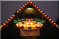
Backwell Parish Hall
A festive message to be seen on the side of the village hall in Backwell, a village dating back to at least 1086. See link below for a clearer idea of the Hall's location.
http://www.geograph.org.uk/photo/100452
Image: © MD
Taken: 20 Dec 2008
0.02 miles
2
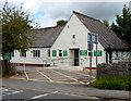
Backwell WI Hall
The WI (Women's Institute) hall is at the SE end of Station Road, near crossroads.
The hall is available for hire. Facilities include a main hall (capacity 100), a meeting room (capacity 16) and a stage with stage lighting.
Image: © Jaggery
Taken: 13 Jul 2012
0.04 miles
3
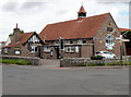
Backwell Parish Hall
Located at the SE end of Station Road, at crossroads in the centre of the village.
The Parish Hall is available for hire. Capacities are:
Main hall (120) meeting room (12) and committee room (20).
Image: © Jaggery
Taken: 13 Jul 2012
0.04 miles
4
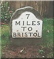
Old Milestone, A370, Farleigh Road, Backwell
The milestone is located a short distance from the crossroads, on the grass verge in front of a wooden fence, on the south east side of the road. Parish of Backwell (North Somerset District). Metal plate attached to stone post, Bristol iron plate design, erected by the Bristol turnpike trust in the 19th century.
Inscription reads:-
7
MILES
TO
BRISTOL
Milestone Society National ID: SO_BRWS07
Image: © JR Dowding
Taken: 28 Dec 2002
0.05 miles
5
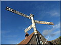
Direction Sign ? Signpost on the A370 Farleigh Road in Backwell parish
Located on the north side of the junction of the A370 Farleigh Road, Station Road and Dark Lane in Backwell parish. 3 arms and pyramid finial.
Milestone Society National ID: SO_ST4868
Image: © Roadside Relics
Taken: 2 Nov 2021
0.05 miles
6
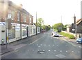
Backwell : Station Road
Looking down Station Road with an estate agents on the left. This is taken from West Town Road.
Image: © Lewis Clarke
Taken: 28 Apr 2011
0.05 miles
7
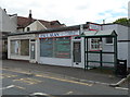
Two shops and a bus shelter, Station Road, Backwell
Located at the SE end of Station Road, near crossroads. The Paul Alan Construction Limited shop was formerly occupied by Backwell Library. After its closure, a Library Access Point was opened at Backwell Leisure Centre, where books, CDs and DVDs can be borrowed or hired. The mobile library makes weekly visits to Backwell.
Next door is Clear Complexion Beauty Salon.
Image: © Jaggery
Taken: 13 Jul 2012
0.06 miles
8
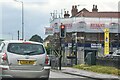
Backwell : Farleigh Road A370
Looking along Farleigh Road at the traffic lights.
Image: © Lewis Clarke
Taken: 11 Jul 2023
0.06 miles
9
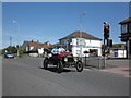
Vintage motor car passes through Backwell
Image: © Roger Cornfoot
Taken: 6 May 2013
0.07 miles
10
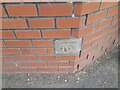
Ordnance Survey Cut Mark
This OS cut mark can be found on the wall of No2 West Town Road. It marks a point 26.938m above mean sea level.
Image: © Adrian Dust
Taken: 30 Jul 2022
0.07 miles