IMAGES TAKEN NEAR TO
Stancombe Lane, BRISTOL, BS48 3QB
Introduction
This page details the photographs taken nearby to Stancombe Lane, BS48 3QB by members of the Geograph project.
The Geograph project started in 2005 with the aim of publishing, organising and preserving representative images for every square kilometre of Great Britain, Ireland and the Isle of Man.

There are currently over 7.5m images from over14,400 individuals and you can help contribute to the project by visiting https://www.geograph.org.uk
Image Map
Images are licensed for reuse under creativecommons.org/licenses/by-sa/2.0
Notes
- Clicking on the map will re-center to the selected point.
- The higher the marker number, the further away the image location is from the centre of the postcode.
Image Listing (13 Images Found)
Images are licensed for reuse under creativecommons.org/licenses/by-sa/2.0
Image
Details
Distance
1
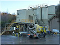
Tarmac's concrete plant in Stancombe Quarry
Known variously as Stancombe or Flax Bourton plant, it supplies the surrounding area with readymix.
Image: © Richard Law
Taken: 11 Jan 2011
0.15 miles
2
Too big for squirrels
Don't think there are any bears in Bourton Combe either.
Image: © Neil Owen
Taken: 29 Nov 2017
0.15 miles
3
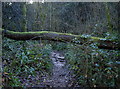
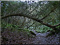
Something about the soil?
Bourton Combe is a shallow valley in an old woodland but the path through it is lined with fallen trees that go right across it.
Image: © Neil Owen
Taken: 29 Nov 2017
0.16 miles
4
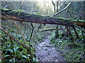
Above head height
Fallen trees are plentiful in Bourton Combe, and many land right across the pathway. Fortunately, they are normally high enough above it for pain-free access.
Image: © Neil Owen
Taken: 29 Nov 2017
0.16 miles
5
Skeletal tree
The path through Bourton Combe has lots of trees that are draped over it and form natural arches. This one is somewhat redolent of some dinosaur skeleton.
Image: © Neil Owen
Taken: 29 Nov 2017
0.16 miles
6

Bourton Combe
A leafy and secluded valley with a number of different tree species and some old quarrying.
Image: © Neil Owen
Taken: 29 Nov 2017
0.16 miles
7
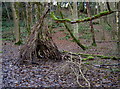
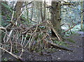
Setting up a new camp?
A little bit of jungle craft has been employed. No sign of any occupants, though.
Image: © Neil Owen
Taken: 29 Nov 2017
0.18 miles
9
The combe lined with fallen trees
Bourton Combe does not appear to be a particularly popular place to walk through as it is somewhat off the beaten track. It also has plenty of trees that have fallen across the bridleway.
Image: © Neil Owen
Taken: 29 Nov 2017
0.20 miles
10
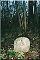
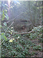
Old Boundary Marker in Bourton Combe
Estate Boundary Marker on the east side of a footpath west down the west side of Bourton Combe. Flax Bourton parish. Inscribed S.
Milestone Society National ID: SO_FB02em
Image: © Miss Worth
Taken: Unknown
0.23 miles