IMAGES TAKEN NEAR TO
Oakleigh Close, BRISTOL, BS48 3JX
Introduction
This page details the photographs taken nearby to Oakleigh Close, BS48 3JX by members of the Geograph project.
The Geograph project started in 2005 with the aim of publishing, organising and preserving representative images for every square kilometre of Great Britain, Ireland and the Isle of Man.

There are currently over 7.5m images from over14,400 individuals and you can help contribute to the project by visiting https://www.geograph.org.uk
Image Map (Loading...)


Getting Data...Please wait
Leaflet Map data © OpenStreetMap
Images are licensed for reuse under creativecommons.org/licenses/by-sa/2.0
Notes
- Clicking on the map will re-center to the selected point.
- The higher the marker number, the further away the image location is from the centre of the postcode.
Image Listing (19 Images Found)
Images are licensed for reuse under creativecommons.org/licenses/by-sa/2.0
Image
Details
Distance
3
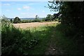
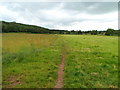
Footpath above Backwell
Footpath above the village of Backwell following the field edge below Backwell Hill Wood
Image: © Philip Halling
Taken: 17 Jul 2014
0.16 miles
4
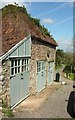
Garages above Backwell
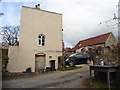
At the top of Hillside Road (background), in what looks like a converted barn.
Image: © Derek Harper
Taken: 3 May 2016
0.19 miles
6
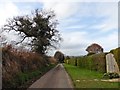
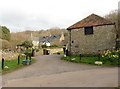
Track SW from Church Town, Backwell
Part of a roughly circular route named the Backwell Round.
Image: © Jaggery
Taken: 13 Jul 2012
0.22 miles
7
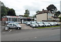
Ettrick Garages, Backwell
Car sales business at 35 West Town Road.
Image: © Jaggery
Taken: 13 Jul 2012
0.22 miles
8
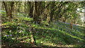
Bluebells by Breakneck
The path up (or down from) Backwell Hill here is known as Breakneck.
Image: © Derek Harper
Taken: 3 May 2016
0.23 miles
9
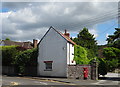
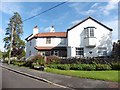
House on Church Lane, Backwell
Showing position of Postbox No. BS48 319.
See Image] for postbox.
Image: © JThomas
Taken: 12 Jul 2019
0.23 miles