IMAGES TAKEN NEAR TO
Church Lane, BRISTOL, BS48 3JJ
Introduction
This page details the photographs taken nearby to Church Lane, BS48 3JJ by members of the Geograph project.
The Geograph project started in 2005 with the aim of publishing, organising and preserving representative images for every square kilometre of Great Britain, Ireland and the Isle of Man.

There are currently over 7.5m images from over14,400 individuals and you can help contribute to the project by visiting https://www.geograph.org.uk
Image Map (Loading...)


Getting Data...Please wait
Leaflet Map data © OpenStreetMap
Images are licensed for reuse under creativecommons.org/licenses/by-sa/2.0
Notes
- Clicking on the map will re-center to the selected point.
- The higher the marker number, the further away the image location is from the centre of the postcode.
Image Listing (94 Images Found)
Images are licensed for reuse under creativecommons.org/licenses/by-sa/2.0
Image
Details
Distance
1
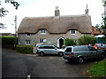
Thatched cottage in Backwell
Viewed from Church Lane.
Image: © Jaggery
Taken: 13 Jul 2012
0.01 miles
2
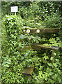
Going out of stile
Why use this awkward wooden trip hazard when the adjacent private road is not gated?
Image: © Neil Owen
Taken: 31 May 2018
0.04 miles
3
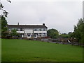
Backwell Junior school's new buildings
Looking from Church Town across the grass area to the extension.
Image: © Neil Owen
Taken: 31 May 2018
0.05 miles
4
Backwell Church of England Primary School
Image: © FollowMeChaps
Taken: 12 Jan 2006
0.06 miles
5
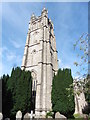
Bell Tower, St Andrew's Church, Backwell
Image: © Roger Cornfoot
Taken: 26 Aug 2020
0.07 miles
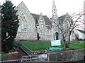
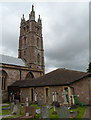
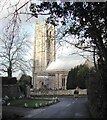
6
Grade I listed St Andrew's Church, Backwell
Viewed across Church Lane. The church dates from the 12th or 13th century,
with many later alterations and enlargements, including the erection
in the late 15th century of the tower seen here.
The church was Grade I listed (the highest category) in 1961.
Image: © Jaggery
Taken: 13 Jul 2012
0.07 miles
7
North side of Grade I listed St Andrew's Church, Backwell
Viewed across the churchyard. The church dates from the 12th or 13th century,
with many later alterations and enlargements, including the erection
in the late 15th century of the tower seen here.
The church was Grade I listed (the highest category) in 1961.
Image: © Jaggery
Taken: 13 Jul 2012
0.07 miles
8
Grade I listed St Andrew's Church, Backwell
Viewed across Church Lane. The church dates from the 12th or 13th century,
with many later alterations and enlargements, including the erection
in the late 15th century of the tower seen here.
The church was Grade I listed (the highest category) in 1961.
Image: © Jaggery
Taken: 13 Jul 2012
0.07 miles
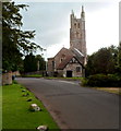
9
St Andrew's church, Backwell
This is the old part of Backwell, Church Lane was originally the main Bristol to Weston road before the A370 took over.
Image: © FollowMeChaps
Taken: 12 Jan 2006
0.07 miles
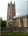
10
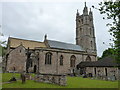
St Andrew's Church, Backwell
Grade I listed https://www.britishlistedbuildings.co.uk/101129810-church-of-st-andrew-backwell#.WywBGdQrLGg in 1961, the church dates from the 12th and 13th centuries, although the tower is more 15th century and was substantially restored in the 1920s. In addition to the external architecture, the interior retains many superb medieval and later fixtures and fittings, and there is a fragment of an 11th century (Norman?) carving incorporated into one of the window frames in the 16th century Rodney Chapel.
Image: © Richard Law
Taken: 14 Jun 2018
0.07 miles