IMAGES TAKEN NEAR TO
The Batch, BRISTOL, BS48 3DL
Introduction
This page details the photographs taken nearby to The Batch, BS48 3DL by members of the Geograph project.
The Geograph project started in 2005 with the aim of publishing, organising and preserving representative images for every square kilometre of Great Britain, Ireland and the Isle of Man.

There are currently over 7.5m images from over14,400 individuals and you can help contribute to the project by visiting https://www.geograph.org.uk
Image Map
Images are licensed for reuse under creativecommons.org/licenses/by-sa/2.0
Notes
- Clicking on the map will re-center to the selected point.
- The higher the marker number, the further away the image location is from the centre of the postcode.
Image Listing (16 Images Found)
Images are licensed for reuse under creativecommons.org/licenses/by-sa/2.0
Image
Details
Distance
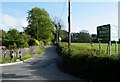
1
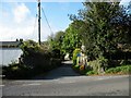
The Batch
A dead end lane off Downside Road in Downside.
Image: © Thomas Nugent
Taken: 8 May 2009
0.08 miles
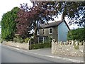
3
Downside Road
Cook's Bridle Path is to the right at the green sogn.
Image: © Thomas Nugent
Taken: 8 May 2009
0.10 miles
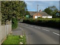
4
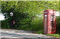
Downside : Downside Road
Downside Road with a lay-by and a red telephone box in view.
Image: © Lewis Clarke
Taken: 13 Jun 2013
0.10 miles
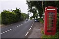
5
Village amenities
Post box, notice board and phone box on Downside Road in Downside.
Image: © Thomas Nugent
Taken: 8 May 2009
0.11 miles
6
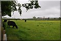
Downside : Grassy Field & Cattle
On a grey wet afternoon looking towards cattle grazing in a field.
Image: © Lewis Clarke
Taken: 13 Jun 2013
0.11 miles
7
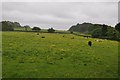
Downside : Grassy Field
A grassy field with some cattle grazing
Image: © Lewis Clarke
Taken: 13 Jun 2013
0.11 miles
8
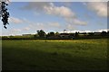
Downside : Grassy Field
A photo taken several hours after Image showing what a difference in weather a short period of time can have.
Image: © Lewis Clarke
Taken: 13 Jun 2013
0.11 miles
9

Downside : Cooks Bridle Path
A road heading towards the golf course and around the perimeter of Bristol Airport.
Image: © Lewis Clarke
Taken: 13 Jun 2013
0.13 miles
10
Cook's Bridle Path
Leads to the golf course from Downside Road.
Image: © Thomas Nugent
Taken: 8 May 2009
0.17 miles